Акс:Geostationaryjava3Dsideview.gif
Нусхаи ҳаҷман ва сифатан баландтар дастрас нест.
Geostationaryjava3Dsideview.gif ((220 × 220 пиксел, ҳаҷми парванда: 111 кбайт, навъи MIME: image/gif), looped, 163 frames, 12 s)
Хулоса
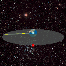
| Тавсифот |
English: A geostationary orbit can only be achieved at an altitude very close to 35,786 km (22,236 mi), and directly above the equator. This equates to an orbital velocity of 3.07 km/s (1.91 mi/s) or a period of 1,436 minutes, which equates to almost exactly one sidereal day or 23.934461223 hours. This makes sense considering that the satellite must be locked to the Earth's rotational period in order to have a stationary footprint on the ground. In practice, this means that all geostationary satellites have to exist on this ring http://weelookang.blogspot.com/2010/07/ejs-open-source-geostationary-satellite.html |
| Сана | |
| Манбаъ | Кори худ |
| Муаллиф | Lookang many thanks to author of original simulation = Francisco Esquembre author of Easy Java Simulation = Francisco Esquembre |
| Иҷозат (Пешроҳандозии ин парванда) |
I, the copyright holder of this work, hereby publish it under the following license: This file is licensed under the Creative Commons Attribution-Share Alike 3.0 Unported license.
|
Таърихи файл
Рӯи таърихҳо клик кунед то нусхаи марбути парвандаро бубинед.
| Таърих | Бандангуштӣ | Андоза | Корбар | Тавзеҳ | |
|---|---|---|---|---|---|
| нусхаи феълӣ | 05:04, 12 июни 2013 | | 220 × 220 (111 кбайт) | Lookang | updated earth texture with public domain better resolution |
| 05:02, 12 июни 2013 |  | 220 × 220 (420 кбайт) | Lookang | updated with public domain earth texture. radius of earth is proportional to geostationary orbit now | |
| 01:29, 27 июни 2011 |  | 220 × 220 (420 кбайт) | Lookang |
Пайвандҳо
Саҳифаҳои зерин ба ин акс пайванданд:
Истифодаи саросарии парванда
Викиҳои дигари зерин ин файлро истифода мекунанд:
- Истифода дар ar.wikipedia.org
- Истифода дар ast.wikipedia.org
- Истифода дар bn.wikipedia.org
- Истифода дар ca.wikipedia.org
- Истифода дар en.wikipedia.org
- Истифода дар eo.wikipedia.org
- Истифода дар es.wikipedia.org
- Истифода дар es.wikiversity.org
- Истифода дар et.wikipedia.org
- Истифода дар fa.wikipedia.org
- Истифода дар fr.wikipedia.org
- Истифода дар gl.wikipedia.org
- Истифода дар he.wikipedia.org
- Истифода дар hi.wikipedia.org
- Истифода дар hu.wikipedia.org
- Истифода дар ml.wikipedia.org
- Истифода дар ms.wikipedia.org
- Истифода дар no.wikipedia.org
- Истифода дар pl.wikipedia.org
- Истифода дар pt.wikipedia.org
- Истифода дар ru.wikipedia.org
- Истифода дар simple.wikipedia.org
- Истифода дар ta.wikipedia.org
- Истифода дар te.wikipedia.org
- Истифода дар th.wikipedia.org
- Истифода дар uk.wikipedia.org
- Истифода дар zh.wikipedia.org