Акс:Anatolia1300.png
Нусхаи ҳаҷман ва сифатан баландтар дастрас нест.
Anatolia1300.png ((535 × 330 пиксел, ҳаҷми парванда: 81 кбайт, навъи MIME: image/png))
Хулоса
| Тавсифот |
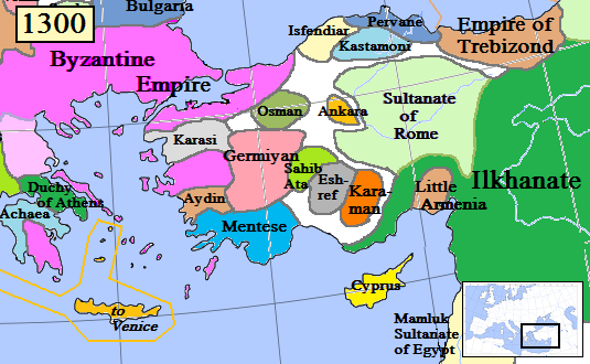
English: Map of the Anatolia region in AD 1300.
(Partially based on Euratlas map of Europe, 1300.) |
| Сана | |
| Манбаъ | Кори худ |
| Муаллиф | Gabagool |
| Other versions |
.png)
Иҷозатнома
I, the copyright holder of this work, hereby publish it under the following license:
This file is licensed under the Creative Commons Attribution 3.0 Unported license.
- Шумо озодед:
- мубодилот намудан – копӣ, паҳн ва фиристадани асар
- ремикс кардан – татбиқи кор
- Under the following conditions:
- тахсис – You must give appropriate credit, provide a link to the license, and indicate if changes were made. You may do so in any reasonable manner, but not in any way that suggests the licensor endorses you or your use.
Таърихи файл
Рӯи таърихҳо клик кунед то нусхаи марбути парвандаро бубинед.
| Таърих | Бандангуштӣ | Андоза | Корбар | Тавзеҳ | |
|---|---|---|---|---|---|
| нусхаи феълӣ | 16:46, 20 Январ 2017 | | 535 × 330 (81 кбайт) | Cplakidas | fixing Dodecanese: Menteshe never controlled the offshore islands; they remained Byzantine until the Hospitallers or Genoese of Chios took them. |
| 22:26, 17 апрели 2009 |  | 535 × 330 (64 кбайт) | Gabagool | Byzantine color lighter. New Armenia -> Little Armenia | |
| 19:12, 2 апрели 2009 |  | 535 × 330 (64 кбайт) | Gabagool | added mamluks | |
| 16:36, 31 марти 2009 |  | 535 × 330 (63 кбайт) | Gabagool | {{Information |Description={{en|1=Map of the Anatolia region in AD 1300. (Partially based on Euratlas map of Europe, 1300.)}} |Source=Own work by uploader |Author=Gabagool |Date=2009-03-31 |Permission= |other_versions= }} <!--{{ImageUp |
Пайвандҳо
Саҳифаҳои зерин ба ин акс пайванданд:
Истифодаи саросарии парванда
Викиҳои дигари зерин ин файлро истифода мекунанд:
- Истифода дар als.wikipedia.org
- Истифода дар ar.wikipedia.org
- Истифода дар arz.wikipedia.org
- Истифода дар azb.wikipedia.org
- Истифода дар ba.wikipedia.org
- Истифода дар bg.wikipedia.org
- Истифода дар bn.wikipedia.org
- Истифода дар ca.wikipedia.org
- Истифода дар cs.wikipedia.org
- Истифода дар de.wikipedia.org
- Истифода дар el.wikipedia.org
- Истифода дар en.wikipedia.org
View more global usage of this file.