Акс:BNR (Ruthienie Blanche) Map 1918.jpg

Акси аслӣ ((4 400 × 3 015 пиксел, ҳаҷми парванда: 10,27 Мбайт, навъи MIME: image/jpeg))
_Map_1918.jpg)
Хулоса
| Унвони мақола |
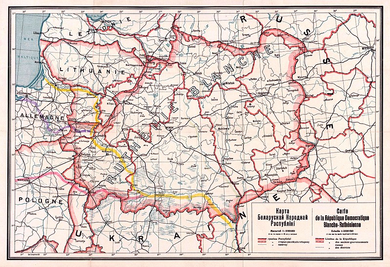
Беларуская: Карта Беларускай Народнай Рэспублікі, 1918 Беларуская (тарашкевіца): Мапа Беларускай Народнай Рэспублікі, 1918
English: Map of the territory claimed by the Belarusian People's Republic (published in 1918).
Русский: Карта Белорусской Народной Республики, 1918
Українська: Карта Білоруської Народної Республіки, 1918 |
| Сана | |
| Манбаъ |
1. Карта БНР 1918 год, IMAGO.BY 2. Originally uploaded to English Wikipedia by Rydel (21:53, 2 January 2005) as en:Image:BNR ruthienie blanche.jpg. |
| Падидоваранда |
Номаълум |
| Georeferencing | If inappropriate please set warp_status = skip to hide. |
Иҷозатнома
|
This work is in the public domain in its country of origin and other countries and areas where the copyright term is the author's life plus 70 years or fewer.
| |
| This file has been identified as being free of known restrictions under copyright law, including all related and neighboring rights. | |
Таърихи файл
Рӯи таърихҳо клик кунед то нусхаи марбути парвандаро бубинед.
| Таърих | Бандангуштӣ | Андоза | Корбар | Тавзеҳ | |
|---|---|---|---|---|---|
| нусхаи феълӣ | 13:56, 26 октябри 2017 | | 4 400 × 3 015 (10,27 Мбайт) | Kazimier Lachnovič | better quality |
| 14:18, 3 сентябри 2005 |  | 1 000 × 700 (195 кбайт) | EugeneZelenko | Map of Belarusian National Republic (published in 1918). Originally uploaded to English Wikipedia by Rydel (21:53, 2 January 2005) as en:Image:BNR ruthienie blanche.jpg. Category:Historical maps of Belarus |
Пайвандҳо
Саҳифаҳои зерин ба ин акс пайванданд:
Истифодаи саросарии парванда
Викиҳои дигари зерин ин файлро истифода мекунанд:
- Истифода дар ar.wikipedia.org
- Истифода дар ast.wikipedia.org
- Истифода дар be-tarask.wikipedia.org
- Истифода дар be.wikipedia.org
- Истифода дар bg.wikipedia.org
- Истифода дар ca.wikipedia.org
- Истифода дар cs.wikipedia.org
- Истифода дар cy.wikipedia.org
- Истифода дар da.wikipedia.org
- Истифода дар de.wikipedia.org
- Истифода дар en.wikipedia.org
- Истифода дар eo.wikipedia.org
- Истифода дар es.wikipedia.org
- Истифода дар et.wikipedia.org
- Истифода дар eu.wikipedia.org
- Истифода дар fr.wikipedia.org
View more global usage of this file.
_Map_1918.jpg)
_Map_1918.jpg)