Акс:China Historic Ming Empire.jpg

Андозаи ин пешнамоиш: 633 × 600 пиксел. Дигар кайфиятҳо: 253 × 240 пиксел | 507 × 480 пиксел | 950 × 900 пиксел.
Акси аслӣ ((950 × 900 пиксел, ҳаҷми парванда: 787 кбайт, навъи MIME: image/jpeg))
| Тавсифот |
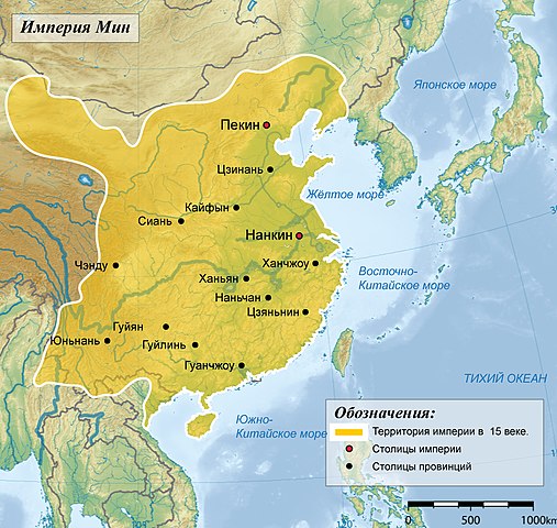
English: Territories of the Ming Empire in 15th century Русский: Территория имерии Мин в 15 веке |
||||||||||
| Сана |
(UTC) 2008-08-17 |
||||||||||
| Манбаъ | |||||||||||
| Муаллиф |
|
||||||||||
| Иҷозат (Пешроҳандозии ин парванда) |
I, the copyright holder of this work, hereby publish it under the following license:
|
||||||||||
| Other versions | Derivative works of this file: Mingská Čína za největšího rozmachu.jpg |

Original upload log
This image is a derivative work of the following images:
- File:China-Historic_macro_areas.svg licensed with GFDL-GMT
- 2008-12-13T16:19:18Z Yug 1438x1047 (3767986 Bytes)
- 2008-12-13T16:01:33Z Yug 1438x1047 (273500 Bytes)
- 2008-12-13T11:38:55Z Yug 1438x1047 (3749701 Bytes) Reverted to version as of 06:33, 12 December 2008
- 2008-12-13T11:25:47Z Yug 1438x1047 (255448 Bytes) Smaller, to fix wikimedia svg to png convertor's limit.
- 2008-12-12T06:33:17Z Yug 1438x1047 (3749701 Bytes) Reverted to version as of 23:19, 2 December 2008
- 2008-12-12T06:30:22Z Yug 2876x2094 (12743592 Bytes)
- 2008-12-02T23:19:46Z Yug 1438x1047 (3749701 Bytes) SVG with smaller Bitmap image embeded inside. To ease usage (wiki bitmap generator script need small SVG to work fine).
- 2008-11-29T23:31:14Z Yug 2876x2094 (12743570 Bytes) {{Information |Description={{en|1=Topographic map of East Asia.}} {{ko|1=동아시아의 지형도.}} |Source=*[[:Image:East_Asia_topographic_map.png|]] |Date=2008-11-29 23:09 (UTC) |Author=*derivative work: ~~~ *[[:Image:Eas
Uploaded with derivativeFX
Таърихи файл
Рӯи таърихҳо клик кунед то нусхаи марбути парвандаро бубинед.
| Таърих | Бандангуштӣ | Андоза | Корбар | Тавзеҳ | |
|---|---|---|---|---|---|
| нусхаи феълӣ | 10:44, 6 марти 2009 | | 950 × 900 (787 кбайт) | Ahnode | {{Information |Description={{en|1=Territories of the Ming Empire in 15th century}} {{ru|1=Территория имерии Мин в 15 веке}} |Source=*File:China-Historic_macro_areas.svg |Date=2009-03-06 10:43 (UTC) |Author=*[[:File:China-Hist |
Пайвандҳо
Саҳифаҳои зерин ба ин акс пайванданд:
Истифодаи саросарии парванда
Викиҳои дигари зерин ин файлро истифода мекунанд:
- Истифода дар ba.wikipedia.org
- Истифода дар be-tarask.wikipedia.org
- Истифода дар be.wikipedia.org
- Истифода дар bxr.wikipedia.org
- Истифода дар ce.wikipedia.org
- Истифода дар cv.wikipedia.org
- Истифода дар da.wikipedia.org
- Истифода дар he.wikipedia.org
- Истифода дар hy.wikipedia.org
- Истифода дар ka.wikipedia.org
- Истифода дар ko.wikipedia.org
- Истифода дар no.wikipedia.org
- Истифода дар ru.wikipedia.org
- Истифода дар ru.wiktionary.org
- Истифода дар tt.wikipedia.org
- Истифода дар uk.wikipedia.org
- Истифода дар xmf.wikipedia.org