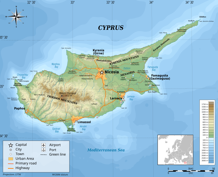
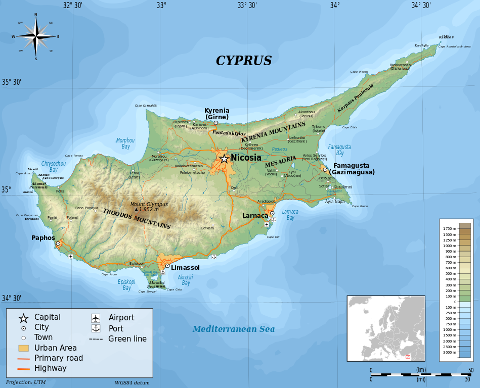
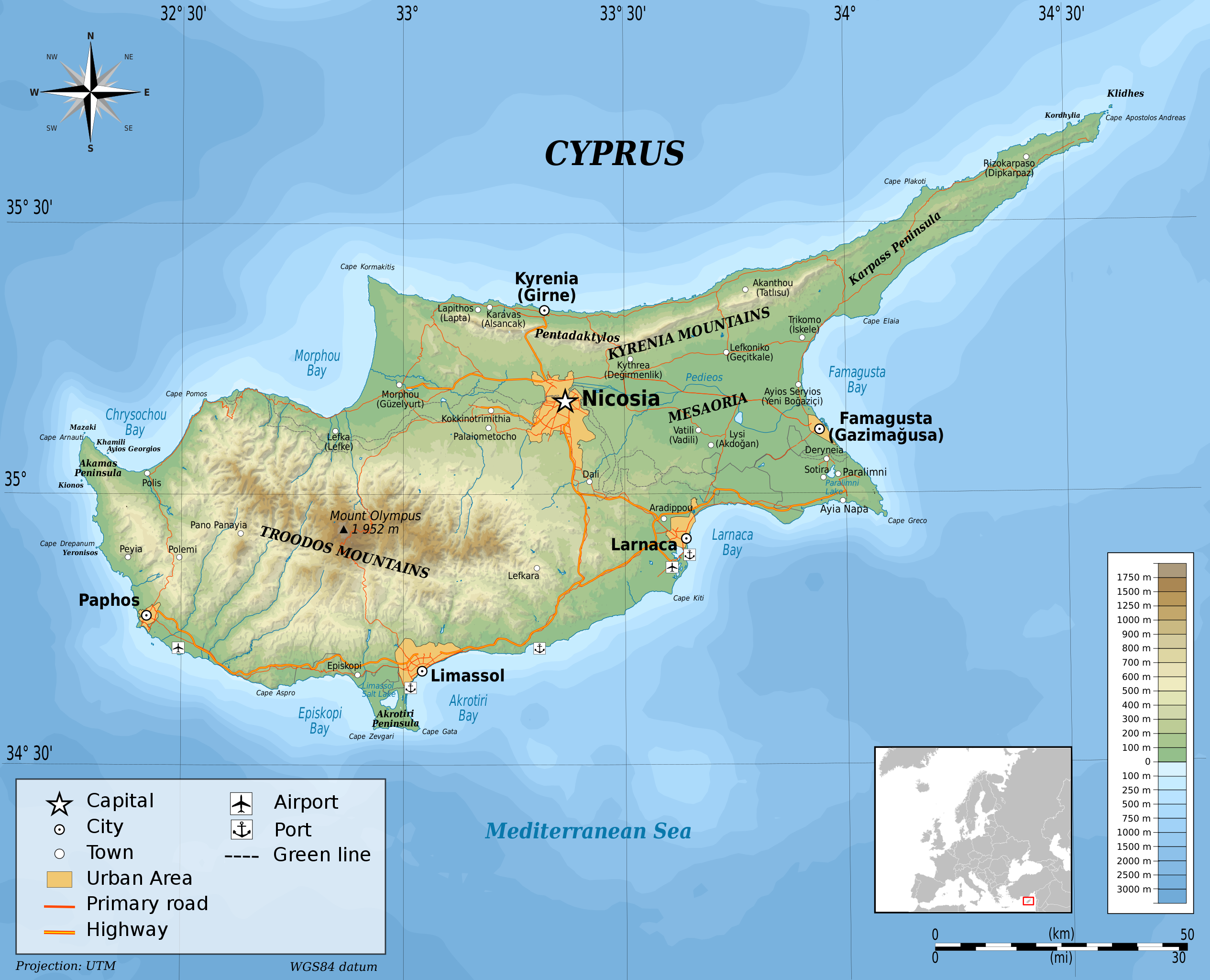
Акс:Cyprus-topographic map-en.svg

Ҳаҷми пешнамоиши PNG барои файли кунунии SVG: 741 × 600 пиксел. Дигар кайфиятҳо: 297 × 240 пиксел | 593 × 480 пиксел | 949 × 768 пиксел | 1 265 × 1 024 пиксел | 2 530 × 2 048 пиксел | 2 028 × 1 642 пиксел.
Акси аслӣ (SVG парванда, исмӣ 2 028 × 1 642 пиксел, андозаи парванда: 3,15 Мбайт)
Хулоса
| Тавсифот |
English: Topographic map of Cyprus Français : Carte topographique de Chypre
UTM projection, WGS84 datum Geographic limits of the map:
|
| Сана | |
| Манбаъ |
Кори худ Sources of data:
|
| Муаллиф | Ikonact |

|
This SVG file contains embedded text that can be translated into your language, using any capable SVG editor, text editor or the SVG Translate tool. For more information see: About translating SVG files. |
W3C-validity not checked.
Иҷозатнома
I, the copyright holder of this work, hereby publish it under the following license:
This file is licensed under the Creative Commons Attribution-Share Alike 3.0 Unported license.
- Шумо озодед:
- мубодилот намудан – копӣ, паҳн ва фиристадани асар
- ремикс кардан – татбиқи кор
- Under the following conditions:
- тахсис – You must give appropriate credit, provide a link to the license, and indicate if changes were made. You may do so in any reasonable manner, but not in any way that suggests the licensor endorses you or your use.
- саҳми яксон – If you remix, transform, or build upon the material, you must distribute your contributions under the same or compatible license as the original.
Таърихи файл
Рӯи таърихҳо клик кунед то нусхаи марбути парвандаро бубинед.
| Таърих | Бандангуштӣ | Андоза | Корбар | Тавзеҳ | |
|---|---|---|---|---|---|
| нусхаи феълӣ | 20:28, 4 сентябри 2014 | | 2 028 × 1 642 (3,15 Мбайт) | Ikonact | valid svg |
| 07:51, 1 сентябри 2014 |  | 2 028 × 1 642 (2,94 Мбайт) | Ikonact | bathymetry correction | |
| 22:23, 31 августи 2014 |  | 2 028 × 1 642 (3,17 Мбайт) | Ikonact | better quality, more geographic names | |
| 23:12, 29 августи 2014 |  | 2 028 × 1 642 (3,07 Мбайт) | Ikonact | more names added | |
| 20:09, 29 августи 2014 |  | 2 028 × 1 642 (3,05 Мбайт) | Ikonact | names of mountains | |
| 17:51, 29 августи 2014 |  | 2 028 × 1 642 (3,05 Мбайт) | Ikonact | names placed correctly | |
| 08:26, 4 май 2014 |  | 2 028 × 1 642 (3,05 Мбайт) | Fern 24 | Uploaded wrong version. | |
| 08:16, 4 май 2014 |  | 2 028 × 1 642 (3,05 Мбайт) | Fern 24 | Fixed typos, aligned and repositioned a few labels. | |
| 21:19, 5 ноябри 2012 |  | 2 028 × 1 642 (3,05 Мбайт) | Ikonact | User created page with UploadWizard |
Пайвандҳо
Саҳифаҳои зерин ба ин акс пайванданд:
Истифодаи саросарии парванда
Викиҳои дигари зерин ин файлро истифода мекунанд:
- Истифода дар el.wikipedia.org
- Истифода дар en.wikipedia.org
- User:Dimadick
- User:Dan Koehl
- User:Harry Wood
- User:PaulinSaudi
- User:Radagast
- User:Sjc196
- User:Pepoluan
- Wikipedia:WikiProject Maps
- User:BrendanRyan
- User:Spicyjack
- User:Jusjih
- User:Acad Ronin
- User:Skal
- User:Steve Farrell
- User:Ranma9617
- User:Jaques O. Carvalho
- User:Ua747sp
- User:AlexTheMartian
- User:Rashed
- User:Professorbikeybike
- User:Saga City
- User:Mikeaitch
- User:Flyingcheese
- User:Parihav
- User:Tabletop
- User:Makaristos
- User:Njk
- User:Spellcheck
- User:Riadlem
- User:Mukkakukaku
- User:Mjvan12
- User:Jared Preston
- User:N8foo
- User:Epolk
- User:Gcapp1959
- User:Toucan6
- User:Kasper Holl
- User:Petros63
- User:Bradybd
- User:Schzmo
- User:Mysid
- User:Burwellian
- User:Tigershrike
- User:Le Anh-Huy
- User:Kmusser
- User:Chingwakabungya
- User:Scotthatton
- User:HoratioVitero
- User:Ottar~enwiki
View more global usage of this file.