Акс:Free State 2011 population density map.svg

Ҳаҷми пешнамоиши PNG барои файли кунунии SVG: 719 × 599 пиксел. Дигар кайфиятҳо: 288 × 240 пиксел | 576 × 480 пиксел | 921 × 768 пиксел | 1 228 × 1 024 пиксел | 2 456 × 2 048 пиксел | 1 095 × 913 пиксел.
Акси аслӣ (SVG парванда, исмӣ 1 095 × 913 пиксел, андозаи парванда: 554 кбайт)
Хулоса
| Тавсифот |
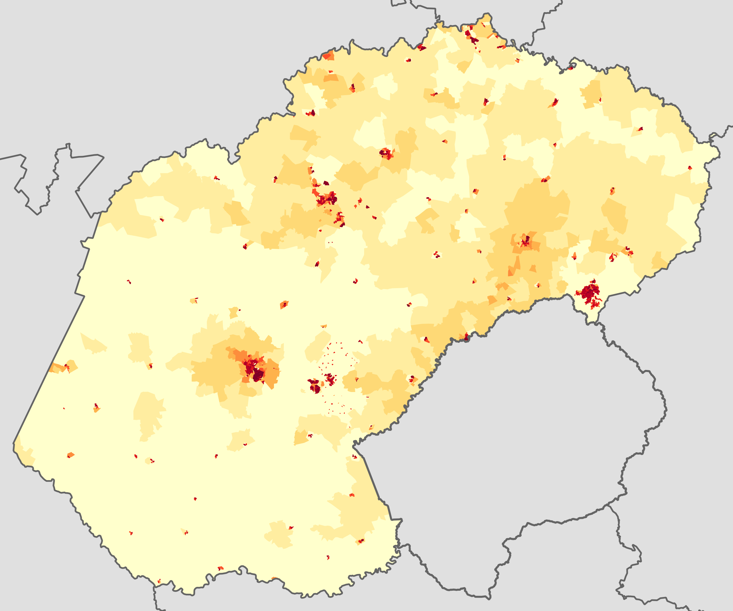
English: Population density map of the Free State province of South Africa, from the 2011 Census, at the "Small Area" level.
<1 inhabitant/km²
1–3 inhabitants/km²
3–10 inhabitants/km²
10–30 inhabitants/km²
30–100 inhabitants/km²
100–300 inhabitants/km²
300–1000 inhabitants/km²
1000–3000 inhabitants/km²
>3000 inhabitants/km²
Projection is Albers Equal-Area Conic, with standard parallels at 25.5° S and 31.5° S, and origin at 28.5° S 25.5° E. |
| Сана | |
| Манбаъ | Statistics South Africa's Census 2011 is the source of the basic population data. The map results from my own processing of the data. |
| Муаллиф | Htonl |
| Иҷозат (Пешроҳандозии ин парванда) |
http://beta2.statssa.gov.za/?page_id=425 |
Иҷозатнома
The following license applies to the population data on which the map is based:

|
The copyright holder of this file, Statistics South Africa (States SA), allows anyone to use it for any purpose, provided that the copyright holder is properly attributed. Redistribution, derivative work, commercial use, and all other use is permitted. |
Тахсис:
Statistics South Africa (States SA)
|
The following tag applies to the map itself:
| I, the copyright holder of this work, release this work into the public domain. This applies worldwide. In some countries this may not be legally possible; if so: I grant anyone the right to use this work for any purpose, without any conditions, unless such conditions are required by law. |
Таърихи файл
Рӯи таърихҳо клик кунед то нусхаи марбути парвандаро бубинед.
| Таърих | Бандангуштӣ | Андоза | Корбар | Тавзеҳ | |
|---|---|---|---|---|---|
| нусхаи феълӣ | 18:27, 22 октябри 2013 | | 1 095 × 913 (554 кбайт) | Htonl | == {{int:filedesc}} == {{Information |Description={{en|1=Population density map of the Free State province of South Africa, from the 2011 Census, at the "Small Area" level. {{legend|#ffffcc|<1 inhabitant/km²}} {{legend|#ffeda0|1–3 inhabitants/km... |
Пайвандҳо
Саҳифаҳои зерин ба ин акс пайванданд:
Истифодаи саросарии парванда
Викиҳои дигари зерин ин файлро истифода мекунанд:
- Истифода дар en.wikipedia.org
- Истифода дар he.wikipedia.org
- Истифода дар hy.wikipedia.org
- Истифода дар ka.wikipedia.org
- Истифода дар ru.wikipedia.org
- Истифода дар vi.wikipedia.org