Акс:Grodno region location map.svg

Ҳаҷми пешнамоиши PNG барои файли кунунии SVG: 502 × 600 пиксел. Дигар кайфиятҳо: 201 × 240 пиксел | 402 × 480 пиксел | 642 × 768 пиксел | 857 × 1 024 пиксел | 1 713 × 2 048 пиксел.
Акси аслӣ (SVG парванда, исмӣ 502 × 600 пиксел, андозаи парванда: 130 кбайт)
Хулоса
| Тавсифот |
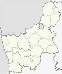
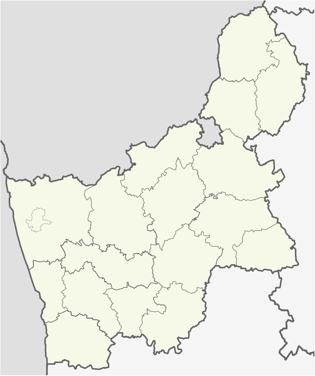
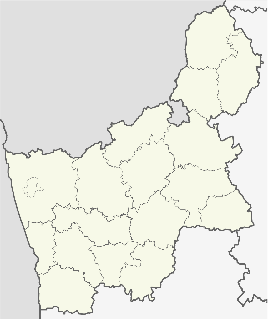
English: Location map of Grodno region
Equirectangular projection. Geographic limits of the map:
|
| Сана | |
| Манбаъ | Own work, based on OpenStreetMap |
| Муаллиф |
V4711 This W3C-unspecified vector image was created with Adobe Illustrator. |
Иҷозатнома
I, the copyright holder of this work, hereby publish it under the following licenses:

|
Permission is granted to copy, distribute and/or modify this document under the terms of the GNU Free Documentation License, Version 1.2 or any later version published by the Free Software Foundation; with no Invariant Sections, no Front-Cover Texts, and no Back-Cover Texts. A copy of the license is included in the section entitled GNU Free Documentation License. |
This file is licensed under the Creative Commons Attribution-Share Alike 4.0 International, 3.0 Unported, 2.5 Generic, 2.0 Generic and 1.0 Generic license.
- Шумо озодед:
- мубодилот намудан – копӣ, паҳн ва фиристадани асар
- ремикс кардан – татбиқи кор
- Under the following conditions:
- тахсис – You must give appropriate credit, provide a link to the license, and indicate if changes were made. You may do so in any reasonable manner, but not in any way that suggests the licensor endorses you or your use.
- саҳми яксон – If you remix, transform, or build upon the material, you must distribute your contributions under the same or compatible license as the original.
Шумо иҷозатномаи хостаи худро интихоб карда метавонед.
Таърихи файл
Рӯи таърихҳо клик кунед то нусхаи марбути парвандаро бубинед.
| Таърих | Бандангуштӣ | Андоза | Корбар | Тавзеҳ | |
|---|---|---|---|---|---|
| нусхаи феълӣ | 21:23, 1 октябри 2015 | | 502 × 600 (130 кбайт) | ערן | removing borders from other countries |
| 03:54, 9 октябри 2014 |  | 502 × 600 (176 кбайт) | V4711 | minor correx | |
| 03:49, 9 октябри 2014 |  | 502 × 600 (176 кбайт) | V4711 | Minor correx | |
| 01:25, 9 октябри 2014 |  | 470 × 560 (145 кбайт) | V4711 | Minor cx | |
| 17:38, 8 октябри 2014 |  | 376 × 449 (145 кбайт) | V4711 | New svg | |
| 10:38, 7 марти 2011 |  | 468 × 559 (3,82 Мбайт) | Чаховіч Уладзіслаў | {{Information |Description ={{en|1={{en|1=Location map of Grodno region}} Equirectangular projection. Geographic limits of the map: * N: 55.03° N * S: 52.71° N * W: 26.75° E * E: 54.28° E}}}} |Source ={{own}} |
Пайвандҳо
Саҳифаҳои зерин ба ин акс пайванданд:
Истифодаи саросарии парванда
Викиҳои дигари зерин ин файлро истифода мекунанд:
- Истифода дар ar.wikipedia.org
- Истифода дар ast.wikipedia.org
- Истифода дар az.wikipedia.org
- Истифода дар ba.wikipedia.org
- Истифода дар be-tarask.wikipedia.org
- Ашмяны
- Наваградак
- Слонім
- Ліда
- Шчучын
- Іўе
- Горадня
- Астравец
- Гальшаны
- Смаргонь
- Альхоўка (Астравецкі раён)
- Бабарыха
- Глінішча (Міхалішкаўскі сельсавет)
- Відзюны
- Вялікае Туроўе
- Бжэгі
- Барынова
- Баравыя (Астравецкі раён)
- Бабічы (Міхалішкаўскі сельсавет)
- Дваржышча
- Дубнікі (Міхалішкаўскі сельсавет)
- Жукойні
- Залуцкоўшчына
- Заборцы (Астравецкі раён)
- Забелішкі (вёска)
- Радзюшы-Тушча
- Радзюшы
- Малое Туроўе
- Лазавыя (Міхалішкаўскі сельсавет)
- Купшчына
- Крываносы (Гарадзенская вобласьць)
- Каценавічы
- Кайміна Дольная
- Супраненты
- Хацілкі
- Тумкі
- Завідзіненты
- Недрашля
- Лягаўцы
- Ласі (Гарадзенская вобласьць)
- Міхалішкі
- Лукавыя
- Маркуны
- Мельніца Сарочча
- Мілайшуны (Міхалішкаўскі сельсавет)
View more global usage of this file.