Акс:Grossgliederung Europas.png
Андозаи ин пешнамоиш: 578 × 600 пиксел. Дигар кайфиятҳо: 231 × 240 пиксел | 462 × 480 пиксел | 740 × 768 пиксел | 987 × 1 024 пиксел | 1 896 × 1 968 пиксел.
Акси аслӣ ((1 896 × 1 968 пиксел, ҳаҷми парванда: 1,71 Мбайт, навъи MIME: image/png))
Хулоса
| Тавсифот |
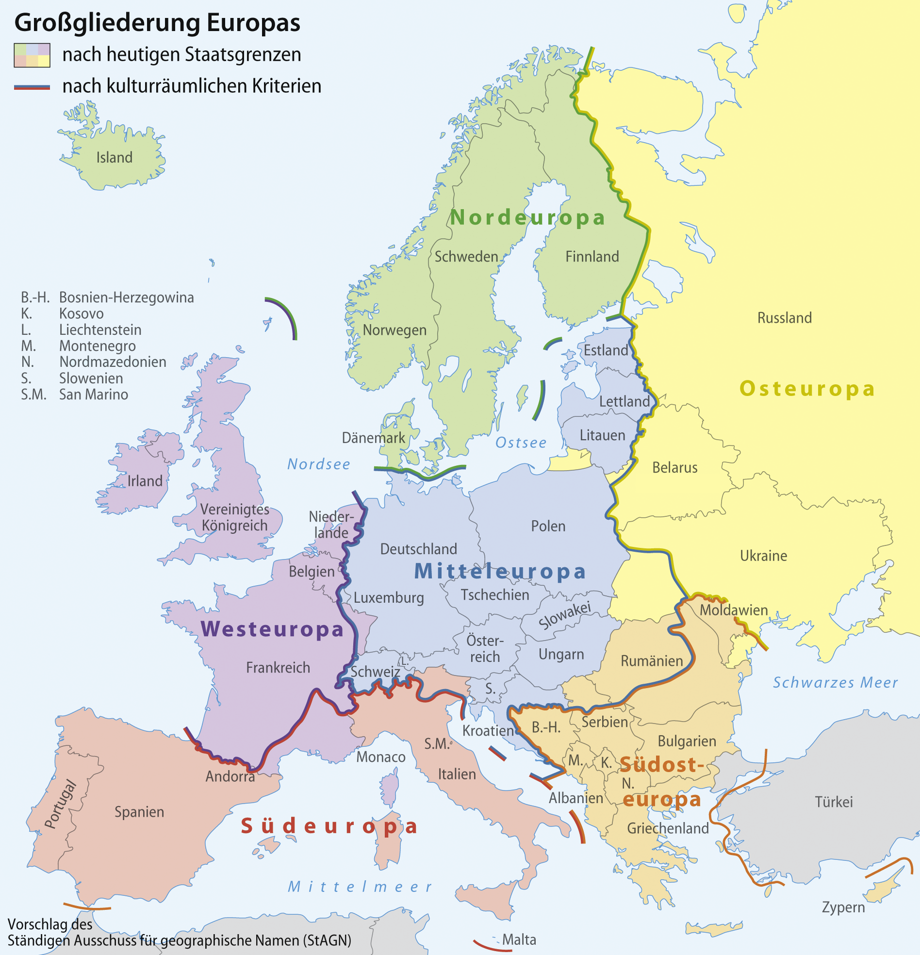
[] Aragonés: Rechions europeyas proposatas por Ständiger Ausschuss für geographische Namen (StAGN) Català: Regions europees proposades per Ständiger Ausschuss für geographische Namen (StAGN) Deutsch: Großgliederung Europas, Vorschlag des Ständigen Ausschuss für geographische Namen (StAGN) English: European regions as proposed by Ständiger Ausschuss für geographische Namen (StAGN) Español: Regiones europeas propuestas por Ständiger Ausschuss für geographische Namen (StAGN) Français : Carte des régions d'Europe, en allemand, selon le Ständigen Ausschuss für geographische Namen (StAGN) Hrvatski: Pregled europskih regija po kriterijima kulture i po državnim granicama Polski: Mapa regionów europejskich, w języku niemieckim, wg propozycjiStałego Komitetu ds. Nazw Geograficznych (StAGN) Македонски: Карта на регионите во Европа според ЕУ на македонски. Русский: Европейские регионы Українська: Європейські регіони на основі пропозиції Ständiger Ausschuss für geographische Namen (StAGN) 中文: 欧洲 العربية : خارطة مناطق ودُول أوروپَّا وفقًا لِمُؤسسة Ständiger Ausschuss für geographische Namen (StAGN) |
| Сана | |
| Манбаъ |
self-made, based on an idea by Lencer using
|
| Муаллиф | NordNordWest |
| Other versions |
[]
|


|
This map has been made or improved in the German Kartenwerkstatt (Map Lab). You can propose maps to improve as well.
|
Иҷозатнома
I, the copyright holder of this work, hereby publish it under the following licenses:

|
Permission is granted to copy, distribute and/or modify this document under the terms of the GNU Free Documentation License, Version 1.2 or any later version published by the Free Software Foundation; with no Invariant Sections, no Front-Cover Texts, and no Back-Cover Texts. A copy of the license is included in the section entitled GNU Free Documentation License. |
This file is licensed under the Creative Commons Attribution-Share Alike 3.0 Unported license.
- Шумо озодед:
- мубодилот намудан – копӣ, паҳн ва фиристадани асар
- ремикс кардан – татбиқи кор
- Under the following conditions:
- тахсис – You must give appropriate credit, provide a link to the license, and indicate if changes were made. You may do so in any reasonable manner, but not in any way that suggests the licensor endorses you or your use.
- саҳми яксон – If you remix, transform, or build upon the material, you must distribute your contributions under the same or compatible license as the original.
Шумо иҷозатномаи хостаи худро интихоб карда метавонед.
Таърихи файл
Рӯи таърихҳо клик кунед то нусхаи марбути парвандаро бубинед.
| Таърих | Бандангуштӣ | Андоза | Корбар | Тавзеҳ | |
|---|---|---|---|---|---|
| нусхаи феълӣ | 18:25, 9 августи 2022 | | 1 896 × 1 968 (1,71 Мбайт) | NordNordWest | c |
| 09:06, 1 апрели 2008 |  | 1 896 × 1 968 (1,71 Мбайт) | NordNordWest | ||
| 08:31, 1 апрели 2008 |  | 1 897 × 1 968 (1,71 Мбайт) | NordNordWest | ||
| 20:50, 31 марти 2008 |  | 1 897 × 1 968 (1,69 Мбайт) | NordNordWest | {{Information |Description= {{de}} Großgliederung Europas, Vorschlag des Ständigen Ausschuss für geographische Namen (StAGN) {{en}} European regions as proposed by Ständiger Ausschuss für geograp |
Пайвандҳо
Саҳифаҳои зерин ба ин акс пайванданд:
Истифодаи саросарии парванда
Викиҳои дигари зерин ин файлро истифода мекунанд:
- Истифода дар als.wikipedia.org
- Истифода дар ba.wikipedia.org
- Истифода дар be-tarask.wikipedia.org
- Истифода дар be.wikipedia.org
- Истифода дар bg.wikipedia.org
- Истифода дар bi.wikipedia.org
- Истифода дар bm.wikipedia.org
- Истифода дар br.wikipedia.org
- Истифода дар bs.wikipedia.org
- Истифода дар cbk-zam.wikipedia.org
- Истифода дар co.wikipedia.org
- Истифода дар csb.wikipedia.org
- Истифода дар cs.wikipedia.org
- Истифода дар cy.wikipedia.org
- Истифода дар de.wikipedia.org
- Nordeuropa
- Mitteleuropa
- Osteuropa
- Westeuropa
- Südosteuropa
- Iberische Halbinsel
- Südeuropa
- Nordosteuropa
- Diskussion:Siebenbürger Sachsen
- Ostmitteleuropa
- Benutzer:Daniel FR/Insel
- Nordwesteuropa
- Diskussion:Balkanhalbinsel/Archiv
- Vorlage:Navigationsleiste Regionen Europas
- Geographie Europas
- Diskussion:Europa/Archiv/1
- Westmitteleuropa
- Diskussion:Lettland/Archiv/1
- Benutzer:Ulflulfl/Karten
- Das neue Europa
- Wikipedia Diskussion:WikiProjekt Geographie/Archiv/2011-1
- Benutzerin:Ra'ike/Liste von Typlokalitäten
- Benutzer:Chris.urs-o/Liste von Typlokalitäten (Mitteleuropa und Südosteuropa)
- Benutzer:Chris.urs-o/Liste von Typlokalitäten (Nordeuropa, Südeuropa und Westeuropa)
- Regionale Gliederung
- Wikipedia:Kartenwerkstatt/Archiv/Zurückgewiesene und zurückgestellte Aufträge 2013
- Eurocup 2013/14
- Zeittafel der Menschheitsgeschichte
- Eurocup 2014/15
View more global usage of this file.