Акс:Lake Athabasca, Canada.jpg

Андозаи ин пешнамоиш: 800 × 338 пиксел. Дигар кайфиятҳо: 320 × 135 пиксел | 640 × 270 пиксел | 1 156 × 488 пиксел.
Акси аслӣ ((1 156 × 488 пиксел, ҳаҷми парванда: 173 кбайт, навъи MIME: image/jpeg))
Хулоса
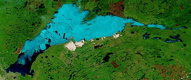
| Тавсифот | Lake Athabasca, Canada. Lake Athabasca straddles the border between Alberta (west) and Saskatchewan (east) - the black line. In the false-color image, vegetation is green, water is dark blue, and ice (or snow) is light blue. |
| Сана | Visualization Date: 2002-06-18 |
| Манбаъ | Visible Earth, NASA (extract) |
| Муаллиф | Jacques Descloitres, MODIS Land Rapid Response Team, NASA/GSFC |
Cropped from the original 4800 x 3600 JPEG (4.4MB) image.
Иҷозатнома
| This file is in the public domain in the United States because it was solely created by NASA. NASA copyright policy states that "NASA material is not protected by copyright unless noted". (See Template:PD-USGov, NASA copyright policy page or JPL Image Use Policy.) | ||
 |
Warnings:
|
Таърихи файл
Рӯи таърихҳо клик кунед то нусхаи марбути парвандаро бубинед.
| Таърих | Бандангуштӣ | Андоза | Корбар | Тавзеҳ | |
|---|---|---|---|---|---|
| нусхаи феълӣ | 11:37, 18 августи 2006 | | 1 156 × 488 (173 кбайт) | Feydey | {{Information |Description= Lake Athabasca, Canada. Lake Athabasca straddles the border between Alberta (west) and Saskatchewan (east) - the black line. In the false-color image, vegetation is green, water is dark blue, and ice (or snow) is light blue. |S |
Пайвандҳо
Саҳифаҳои зерин ба ин акс пайванданд:
Истифодаи саросарии парванда
Викиҳои дигари зерин ин файлро истифода мекунанд:
- Истифода дар af.wikipedia.org
- Истифода дар ar.wikipedia.org
- Истифода дар arz.wikipedia.org
- Истифода дар be.wikipedia.org
- Истифода дар bg.wikipedia.org
- Истифода дар bn.wikipedia.org
- Истифода дар bs.wikipedia.org
- Истифода дар ca.wikipedia.org
- Истифода дар ceb.wikipedia.org
- Истифода дар cv.wikipedia.org
- Истифода дар cy.wikipedia.org
- Истифода дар da.wikipedia.org
- Истифода дар el.wikipedia.org
- Истифода дар en.wikipedia.org
- Истифода дар eo.wikipedia.org
- Истифода дар es.wikipedia.org
- Истифода дар eu.wikipedia.org
- Истифода дар fa.wikipedia.org
- Истифода дар frr.wikipedia.org
- Истифода дар fr.wikipedia.org
- Истифода дар fy.wikipedia.org
- Истифода дар hu.wikipedia.org
- Истифода дар hy.wikipedia.org
- Истифода дар id.wikipedia.org
- Истифода дар incubator.wikimedia.org
- Истифода дар it.wikipedia.org
- Истифода дар ka.wikipedia.org
- Истифода дар kk.wikipedia.org
- Истифода дар ky.wikipedia.org
- Истифода дар lt.wikipedia.org
- Истифода дар lv.wikipedia.org
- Истифода дар nl.wikipedia.org
- Истифода дар no.wikipedia.org
- Истифода дар pl.wikipedia.org
- Истифода дар pl.wiktionary.org
- Истифода дар pnb.wikipedia.org
- Истифода дар pt.wikipedia.org
- Истифода дар ro.wikipedia.org
- Истифода дар ru.wikipedia.org
- Истифода дар sv.wikipedia.org
View more global usage of this file.