Акс:Old Tower night winter 2011 G1.jpg

Андозаи ин пешнамоиш: 431 × 599 пиксел. Дигар кайфиятҳо: 172 × 240 пиксел | 345 × 480 пиксел | 552 × 768 пиксел | 736 × 1 024 пиксел | 1 473 × 2 048 пиксел | 3 200 × 4 450 пиксел.
Акси аслӣ ((3 200 × 4 450 пиксел, ҳаҷми парванда: 3,29 Мбайт, навъи MIME: image/jpeg))
Хулоса
| Тавсифот |
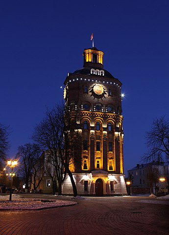
English: The former water tower in the center of Vinnytsia, Ukraine. View in the winter evening. Русский: Старая водонапорная башня в центре города Винницы, Украина. Вид зимним вечером. |
||
| Сана | |||
| Манбаъ | Кори худ | ||
| Муаллиф | George Chernilevsky | ||
| Иҷозат (Пешроҳандозии ин парванда) |
I, the copyright holder of this work, hereby publish it under the following licenses: This file is licensed under the Creative Commons Attribution-Share Alike 4.0 International license.
Шумо иҷозатномаи хостаи худро интихоб карда метавонед. |
||
| Other versions |
|


| Camera location | | View this and other nearby images on: OpenStreetMap |
|---|
| Object location | | View this and other nearby images on: OpenStreetMap |
|---|
Assessment
|
This image was selected as picture of the day on Wikimedia Commons for 25 September 2011. It was captioned as follows: English: The former water tower in the center of Vinnitsa, Ukraine. View in the winter evening. Other languages:
English: The former water tower in the center of Vinnitsa, Ukraine. View in the winter evening. Español: La antigua torre de agua en el centro de Vinnytsia (Ucrania) vista en una tarde de invierno. Italiano: La precedente torre dell'acqua al centro di Vinnitsa, Ucraina, fotografata durante una serata invernale. Nederlands: De voormalige watertoren in het centrum van Vinnytsja, Oekraïne, tijdens een winteravond. 한국어: 우크라이나의 빈니차 도시 중심에 있는 옛 급수탑. 겨울 저녁의 모습이다. 日本語: ウクライナ・ヴィーンヌィツャ中心部に位置する旧給水塔。冬の夜景。 中文: 乌克兰文尼察旧水塔冬季夜景。 עברית : מגדל המים הישן במרכז העיר ויניצה שבאוקראינה בלילה חורפי |

|
This is one of the images forming part of the Valued image set: Water tower in Vinnytsya, exterior on Wikimedia Commons. The image set has been assessed under the valued image set criteria and is considered the most valued set on Commons within the scope:
Water tower in Vinnytsya, exterior
You can see its nomination at Commons:Valued image candidates/Water tower in Vinnytsya. |
Таърихи файл
Рӯи таърихҳо клик кунед то нусхаи марбути парвандаро бубинед.
| Таърих | Бандангуштӣ | Андоза | Корбар | Тавзеҳ | |
|---|---|---|---|---|---|
| нусхаи феълӣ | 07:43, 19 марти 2011 | | 3 200 × 4 450 (3,29 Мбайт) | George Chernilevsky | slight cropped at top |
| 21:36, 29 Январ 2011 |  | 3 200 × 4 600 (3,88 Мбайт) | George Chernilevsky | {{Information |Description ={{en|The former water tower in the center of Vinnitsa, Ukraine. View in the winter evening.}} {{ru|Старая водонапорная башня в центре города Винницы, Украина. Вид зимн |
Пайвандҳо
Ин акс дар ҳеҷ саҳифа истифода намешавад.
Истифодаи саросарии парванда
Викиҳои дигари зерин ин файлро истифода мекунанд:
- Истифода дар ba.wikipedia.org
- Истифода дар be-tarask.wikipedia.org
- Истифода дар bn.wikipedia.org
- Истифода дар crh.wikipedia.org
- Истифода дар cv.wikipedia.org
- Истифода дар en.wikipedia.org
- Истифода дар fi.wikipedia.org
- Истифода дар fr.wikivoyage.org
- Истифода дар hu.wikipedia.org
- Истифода дар kk.wikipedia.org
- Истифода дар ko.wikipedia.org
- Истифода дар krc.wikipedia.org
- Истифода дар lbe.wikipedia.org
- Истифода дар lez.wikipedia.org
- Истифода дар lt.wikipedia.org
- Истифода дар ml.wikipedia.org
- Истифода дар ms.wikipedia.org
- Истифода дар os.wikipedia.org
- Истифода дар pl.wikipedia.org
- Истифода дар pl.wikivoyage.org
- Истифода дар pt.wikipedia.org
- Истифода дар ro.wikipedia.org
- Истифода дар ru.wikipedia.org
- Истифода дар ru.wikinews.org
- Истифода дар sah.wikipedia.org
- Истифода дар sk.wikipedia.org
- Истифода дар tyv.wikipedia.org
- Истифода дар uk.wikipedia.org
- Истифода дар ur.wikipedia.org
- Истифода дар vi.wikipedia.org
- Истифода дар xal.wikipedia.org
- Истифода дар xmf.wikipedia.org
- Истифода дар zh.wikipedia.org