Акс:Population density.png

Андозаи ин пешнамоиш: 800 × 400 пиксел. Дигар кайфиятҳо: 320 × 160 пиксел | 640 × 320 пиксел | 1 024 × 512 пиксел | 1 280 × 640 пиксел | 2 560 × 1 280 пиксел | 4 320 × 2 160 пиксел.
Акси аслӣ ((4 320 × 2 160 пиксел, ҳаҷми парванда: 522 кбайт, навъи MIME: image/png))
Таърихи файл
Рӯи таърихҳо клик кунед то нусхаи марбути парвандаро бубинед.
| Таърих | Бандангуштӣ | Андоза | Корбар | Тавзеҳ | |
|---|---|---|---|---|---|
| нусхаи феълӣ | 00:41, 11 апрели 2013 |  | 4 320 × 2 160 (522 кбайт) | Jahoe | Re-downloaded original from http://eoimages.gsfc.nasa.gov/images/imagerecords/53000/53005/population_density.tif, re-converted to PNG (preserving alpha channel) using tiff2png (by Willem van Schaik and Greg Roelofs). Removed rgb pixel values from fully... |
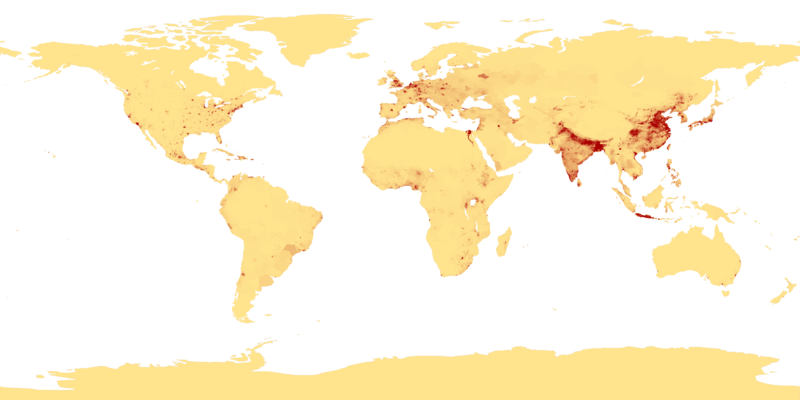
| 03:41, 27 феврали 2007 |  | 4 320 × 2 160 (915 кбайт) | Keenan Pepper | This image shows the number of people per square kilometer around the world in 1994. The data were derived from population records based on political divisions such as states, provinces, and counties. The image was taken from [http://visibleearth.nasa.go |
Пайвандҳо
Саҳифаҳои зерин ба ин акс пайванданд:
Истифодаи саросарии парванда
Викиҳои дигари зерин ин файлро истифода мекунанд:
- Истифода дар als.wikipedia.org
- Истифода дар an.wikipedia.org
- Истифода дар ar.wikipedia.org
- Истифода дар ast.wikipedia.org
- Истифода дар az.wikipedia.org
- Истифода дар be-tarask.wikipedia.org
- Истифода дар be.wikipedia.org
- Истифода дар bg.wikipedia.org
- Истифода дар bh.wikipedia.org
- Истифода дар bn.wikipedia.org
- Истифода дар bs.wikipedia.org
- Истифода дар ca.wikipedia.org
- Истифода дар ce.wikipedia.org
- Истифода дар ckb.wikipedia.org
- Истифода дар cu.wikipedia.org
- Истифода дар cv.wikipedia.org
- Истифода дар da.wikipedia.org
- Истифода дар da.wikibooks.org
- Истифода дар de.wikipedia.org
- Истифода дар dsb.wikipedia.org
- Истифода дар el.wikipedia.org
- Истифода дар en.wikipedia.org
- Истифода дар en.wikiquote.org
- Истифода дар eo.wikipedia.org
- Истифода дар es.wikipedia.org
View more global usage of this file.


