Акс:Batman districts.png

Андозаи ин пешнамоиш: 601 × 599 пиксел. Дигар кайфиятҳо: 241 × 240 пиксел | 481 × 480 пиксел | 780 × 778 пиксел.
Акси аслӣ ((780 × 778 пиксел, ҳаҷми парванда: 18 кбайт, навъи MIME: image/png))

|
This locator map image could be re-created using vector graphics as an SVG file. This has several advantages; see Commons:Media for cleanup for more information. If an SVG form of this image is available, please upload it and afterwards replace this template with
{{vector version available|new image name}}.
It is recommended to name the SVG file “Batman districts.svg”—then the template Vector version available (or Vva) does not need the new image name parameter. |
Хулоса
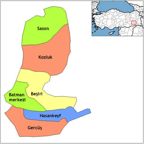
| Тавсифот | Map of the districts of Batman province in Turkey. Created by Rarelibra 18:55, 1 December 2006 (UTC) for public domain use, using MapInfo Professional v8.5 and various mapping resources. Edited by One Homo Sapiens Corrected text where İ,Ş,ı,ğ,or ş occurs in name. Source: [statoids-com]. Increased font size and enhanced color differences among adjacent districts. |
| Сана | 1 Декабр 2006 (original upload date) |
| Манбаъ | No machine-readable source provided. Own work assumed (based on copyright claims). |
| Муаллиф | No machine-readable author provided. Rarelibra assumed (based on copyright claims). |
Иҷозатнома
| I, the copyright holder of this work, release this work into the public domain. This applies worldwide. In some countries this may not be legally possible; if so: I grant anyone the right to use this work for any purpose, without any conditions, unless such conditions are required by law. |
Таърихи файл
Рӯи таърихҳо клик кунед то нусхаи марбути парвандаро бубинед.
| Таърих | Бандангуштӣ | Андоза | Корбар | Тавзеҳ | |
|---|---|---|---|---|---|
| нусхаи феълӣ | 05:42, 10 феврали 2011 | | 780 × 778 (18 кбайт) | Materialscientist | crop whitespace |
| 21:00, 28 Декабри 2008 |  | 1 056 × 816 (19 кбайт) | One Homo Sapiens | Corrected text where İ,Ş,ı,ğ,or ş occurs in name. Source: [statoids-com]. Increased font size and enhanced color differences among adjacent districts. | |
| 18:55, 1 Декабри 2006 |  | 1 056 × 816 (23 кбайт) | Rarelibra | Map of the districts of Batman province in Turkey. Created by ~~~~ for public domain use, using MapInfo Professional v8.5 and various mapping resources. |
Пайвандҳо
Саҳифаҳои зерин ба ин акс пайванданд:
Истифодаи саросарии парванда
Викиҳои дигари зерин ин файлро истифода мекунанд:
- Истифода дар ar.wikipedia.org
- Истифода дар arz.wikipedia.org
- Истифода дар ast.wikipedia.org
- Истифода дар az.wikipedia.org
- Истифода дар bs.wikipedia.org
- Истифода дар ca.wikipedia.org
- Истифода дар ceb.wikipedia.org
- Истифода дар cs.wikipedia.org
- Истифода дар de.wikipedia.org
- Истифода дар diq.wikipedia.org
- Истифода дар en.wikipedia.org
- Истифода дар en.wiktionary.org
- Истифода дар eo.wikipedia.org
- Истифода дар es.wikipedia.org
- Истифода дар eu.wikipedia.org
- Истифода дар fa.wikipedia.org
- Истифода дар fi.wikipedia.org
- Истифода дар fr.wikipedia.org
- Истифода дар hr.wikipedia.org
View more global usage of this file.