Акс:Celtic Sea and Bay of Biscay bathymetric map-en.svg

Ҳаҷми пешнамоиши PNG барои файли кунунии SVG: 548 × 599 пиксел. Дигар кайфиятҳо: 219 × 240 пиксел | 439 × 480 пиксел | 702 × 768 пиксел | 936 × 1 024 пиксел | 1 872 × 2 048 пиксел | 3 479 × 3 805 пиксел.
Акси аслӣ (SVG парванда, исмӣ 3 479 × 3 805 пиксел, андозаи парванда: 4,93 Мбайт)
Хулоса
| Тавсифот |
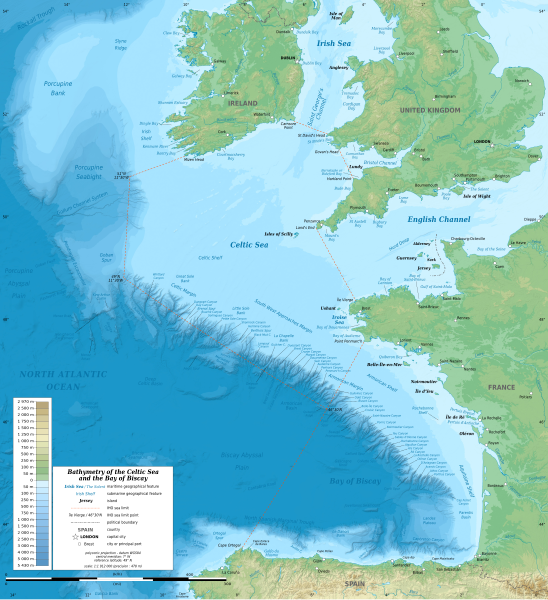
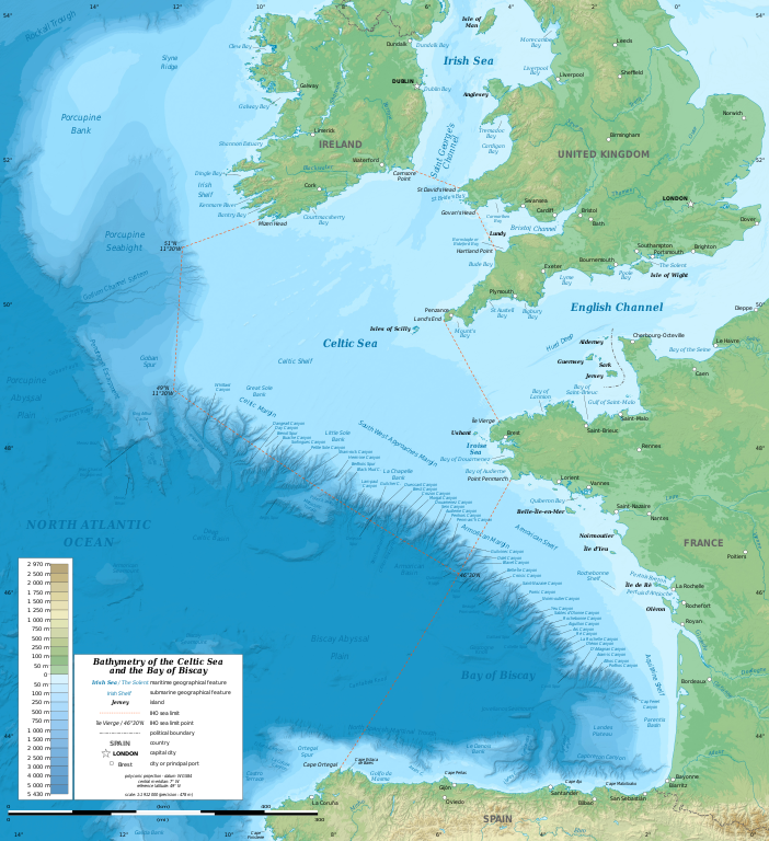
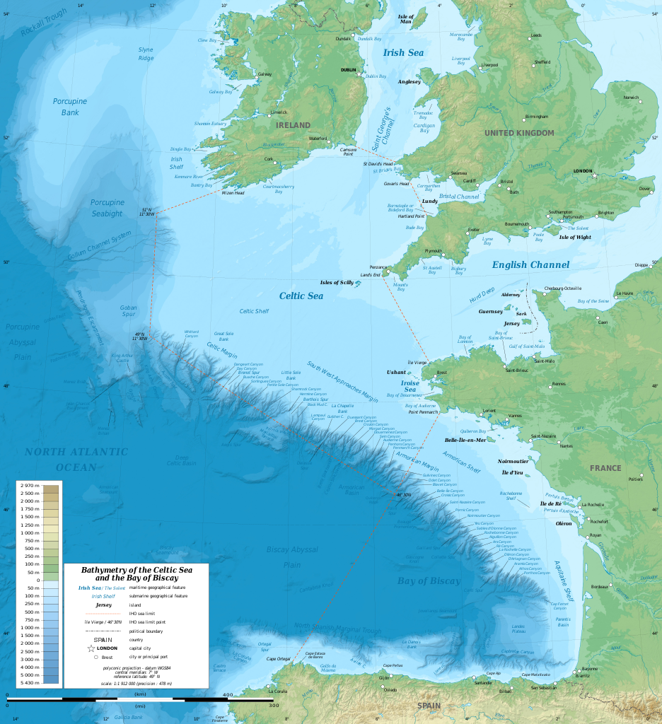
English: Bathymetric map in English of the Celtic Sea and the Bay of Biscay. Limits of the seas as specified by the International Hydrographic Organization.
Note: the background map is a raster image embedded in the SVG file. Français : Carte bathymétrique en anglais de la Mer Celtique et du Golfe de Gascogne. Limites des mers telles que définies par l'Organisation Hydrographique Internationale. Note : le fond de carte est une image bitmap embarquée dans le fichier SVG. |
| Сана | 13:37:01, upgraded 2019-10 |
| Манбаъ | see Celtic Sea and Bay of Biscay bathymetric map-fr.svg |
| Муаллиф | Eric Gaba (Sting - fr:Sting) |
| Other versions |
[]
|
| SVG genesis |


| Camera location | | View this and other nearby images on: OpenStreetMap |
|---|
Иҷозатнома
This file is licensed under the Creative Commons Attribution-Share Alike 3.0 Unported license.
- Шумо озодед:
- мубодилот намудан – копӣ, паҳн ва фиристадани асар
- ремикс кардан – татбиқи кор
- Under the following conditions:
- тахсис – You must give appropriate credit, provide a link to the license, and indicate if changes were made. You may do so in any reasonable manner, but not in any way that suggests the licensor endorses you or your use.
- саҳми яксон – If you remix, transform, or build upon the material, you must distribute your contributions under the same or compatible license as the original.
Таърихи файл
Рӯи таърихҳо клик кунед то нусхаи марбути парвандаро бубинед.
| Таърих | Бандангуштӣ | Андоза | Корбар | Тавзеҳ | |
|---|---|---|---|---|---|
| нусхаи феълӣ | 21:33, 28 октябри 2019 | | 3 479 × 3 805 (4,93 Мбайт) | Sting | New map using GEBCO 15 Sec topographic data ; rivers from ECRINS ; added names |
| 14:34, 3 июли 2014 |  | 1 749 × 1 913 (673 кбайт) | Erigena | minor tweaks | |
| 12:46, 1 июли 2014 |  | 1 749 × 1 913 (614 кбайт) | Erigena | User created page with UploadWizard |
Пайвандҳо
Саҳифаҳои зерин ба ин акс пайванданд:
Истифодаи саросарии парванда
Викиҳои дигари зерин ин файлро истифода мекунанд:
- Истифода дар af.wikipedia.org
- Истифода дар azb.wikipedia.org
- Истифода дар bg.wikipedia.org
- Истифода дар bh.wikipedia.org
- Истифода дар bn.wikipedia.org
- Истифода дар cs.wikipedia.org
- Истифода дар de.wikipedia.org
- Истифода дар en.wikipedia.org
- Истифода дар en.wikiversity.org
- Истифода дар fa.wikipedia.org
- Истифода дар fi.wikipedia.org
- Истифода дар frr.wikipedia.org
- Истифода дар fy.wikipedia.org
- Истифода дар gl.wikipedia.org
- Истифода дар hu.wikipedia.org
- Истифода дар hy.wikipedia.org
- Истифода дар hyw.wikipedia.org
- Истифода дар id.wikipedia.org
- Истифода дар ja.wikipedia.org
- Истифода дар lo.wikipedia.org
- Истифода дар lv.wikipedia.org
- Истифода дар nl.wikipedia.org
- Истифода дар ru.wikipedia.org
- Истифода дар sq.wikipedia.org
- Истифода дар sr.wikipedia.org
- Истифода дар sv.wikipedia.org
- Истифода дар th.wikipedia.org
- Истифода дар tr.wikipedia.org
- Истифода дар uk.wikipedia.org
- Истифода дар vi.wikipedia.org
- Истифода дар vls.wikipedia.org
- Истифода дар www.wikidata.org
- Истифода дар zh-min-nan.wikipedia.org
- Истифода дар zh-yue.wikipedia.org
- Истифода дар zh.wikipedia.org