Акс:Chad location map.svg

Ҳаҷми пешнамоиши PNG барои файли кунунии SVG: 399 × 599 пиксел. Дигар кайфиятҳо: 160 × 240 пиксел | 320 × 480 пиксел | 512 × 768 пиксел | 682 × 1 024 пиксел | 1 365 × 2 048 пиксел | 899 × 1 349 пиксел.
Акси аслӣ (SVG парванда, исмӣ 899 × 1 349 пиксел, андозаи парванда: 294 кбайт)
Хулоса
| Camera location | | View this and other nearby images on: OpenStreetMap |
|---|
| Тавсифот |
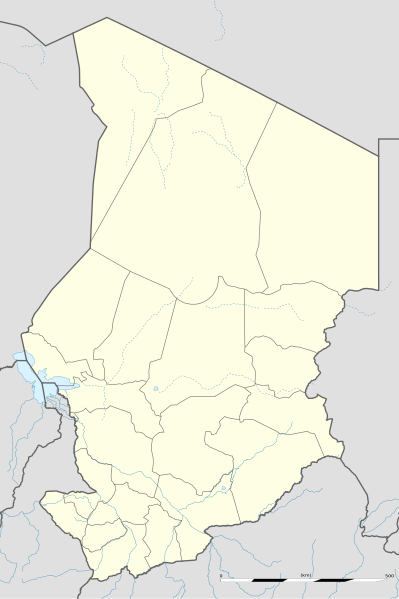
English: Blank administrative map of Chad as since the 2008-02 reform of the Regions, for geo-location purposes.
Français : Carte administrative vierge du Tchad telle que depuis la réforme des Régions de février 2008, destinée à la géolocalisation. Scale: 1:5,600,000 (precision: 1,400 m)
Geographic limits of the map:
|
||
| Сана | 2009-11, updated 2011-07 | ||
| Манбаъ |
Кори худ
|
||
| Муаллиф | Eric Gaba (Sting - fr:Sting) | ||
| Иҷозат (Пешроҳандозии ин парванда) |
|
||
| Other versions |
|

Иҷозатнома
I, the copyright holder of this work, hereby publish it under the following licenses:
This file is licensed under the Creative Commons Attribution-Share Alike 3.0 Unported license.
- Шумо озодед:
- мубодилот намудан – копӣ, паҳн ва фиристадани асар
- ремикс кардан – татбиқи кор
- Under the following conditions:
- тахсис – You must give appropriate credit, provide a link to the license, and indicate if changes were made. You may do so in any reasonable manner, but not in any way that suggests the licensor endorses you or your use.
- саҳми яксон – If you remix, transform, or build upon the material, you must distribute your contributions under the same or compatible license as the original.

|
Permission is granted to copy, distribute and/or modify this document under the terms of the GNU Free Documentation License, Version 1.2 or any later version published by the Free Software Foundation; with no Invariant Sections, no Front-Cover Texts, and no Back-Cover Texts. A copy of the license is included in the section entitled GNU Free Documentation License. |
Шумо иҷозатномаи хостаи худро интихоб карда метавонед.
Таърихи файл
Рӯи таърихҳо клик кунед то нусхаи марбути парвандаро бубинед.
| Таърих | Бандангуштӣ | Андоза | Корбар | Тавзеҳ | |
|---|---|---|---|---|---|
| нусхаи феълӣ | 22:26, 14 июли 2011 | | 899 × 1 349 (294 кбайт) | Sting | Sudan/South Sudan 2011-07 border update |
| 23:28, 23 ноябри 2009 |  | 899 × 1 349 (268 кбайт) | Sting | == {{int:filedesc}} == {{Location|15|27|00|N|18|43|30|E|scale:7000000}} <br/> {{Information |Description={{en|Blank administrative map of Chad as after the 2008-02 reform of the Regions, for geo-location purposes.}} {{fr|Carte administrative |
Пайвандҳо
Саҳифаҳои зерин ба ин акс пайванданд:
Истифодаи саросарии парванда
Викиҳои дигари зерин ин файлро истифода мекунанд:
- Истифода дар af.wikipedia.org
- Истифода дар am.wikipedia.org
- Истифода дар ar.wikipedia.org
- Истифода дар az.wikipedia.org
- Истифода дар ba.wikipedia.org
- Истифода дар be-tarask.wikipedia.org
- Истифода дар be.wikipedia.org
- Истифода дар bg.wikipedia.org
- Истифода дар bn.wikipedia.org
- Истифода дар bs.wikipedia.org
- Истифода дар ceb.wikipedia.org
View more global usage of this file.