Акс:Dominion of Pakistan & Indian Controlled Kashmir (orthographic projection).svg

Ҳаҷми пешнамоиши PNG барои файли кунунии SVG: 541 × 541 пиксел. Дигар кайфиятҳо: 240 × 240 пиксел | 480 × 480 пиксел | 768 × 768 пиксел | 1 024 × 1 024 пиксел | 2 048 × 2 048 пиксел.
Акси аслӣ (SVG парванда, исмӣ 541 × 541 пиксел, андозаи парванда: 396 кбайт)
Хулоса
| Тавсифот |
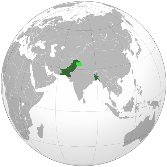
English: Dominion of Pakistan is highlighted in dark green and Indian Controlled Kashmir in light green. This map shows the borders of every countries, political entities and other territories between July 2006 to June 2011, which makes a big mistake. Here is the reason: Dominion of Pakistan existed from 14 August 1947, when it became independent from British India, to 23 March 1956, when it was succeeded by Islamic Republic of Pakistan. Thus, this map should show the borders of every countries, political entities, colonies and other territories at the end of 1955 (see the English Wikipedia articles "List of sovereign states in 1955" and "List of national border changes since World War I"). हिन्दी: पाकिस्तान अधिराज्य अधीन भूमि को गाढ़े हरे रंग में रेखांकित किया गया है, वहीँ भारत शासित कश्मीर हलके हरे रंग में है |
| Сана | Sunday 31 May 2009 (01:06 GMT+1) |
| Манбаъ | Кори худ |
| Муаллиф | SelfQ |
| Other versions |
.svg) |
.svg)
.svg)
.svg)
.svg)
.svg)
.svg)
.svg)
.svg)
.svg)
.svg)
.svg)
.svg)
.svg)
.svg)
.svg)
.svg)
.svg)
.svg)
.svg)
.svg)
.svg)
.svg)
.svg)
.svg)
.svg)
.svg)
.svg)
.svg)
.svg)
.svg)
.svg)
.svg)
.svg)
.svg)
.svg)
.svg)
.svg)
.svg)
.svg)
.svg)
.svg)
.svg)
.svg)
.svg)
.svg)
.svg)
.svg)
.svg)
.svg)
.svg)
.svg)
.svg)
.svg)
.svg)
.svg)
.svg)
.svg)
.svg)
.svg)
.svg)
.svg)
.svg)
.svg)
.svg)
.svg)
.svg)
.svg)
.svg)
.svg)
.svg)
.svg)
.svg)
.svg)

.svg)

.svg)

.svg)
.svg)
.svg)
.svg)
.svg)
.svg)
.svg)


.svg)
.svg)
.svg)
.svg)
.svg)
.svg)
.svg)

.svg)
.svg)
.svg)
.svg)
.svg)
.svg)
.svg)
.svg)
.svg)
.svg)

.svg)
.svg)
.svg)
.svg)
.svg)
.svg)
.svg)
_without_national_boundaries.svg)
.svg)
.svg)
.svg)
.svg)
.svg)
.svg)

.svg)
.svg)
.png)
.svg)
.svg)
.svg)
.svg)

.svg)
.svg)
.svg)
.svg)
.svg)
.svg)
.svg)
.svg)
.svg)
.svg)
.svg)

.svg)
.svg)
.svg)
.svg)
.svg)
.svg)
.svg)
.svg)
.svg)

.svg)
.svg)

.svg)
.svg)
.svg)
.svg)
.svg)
.svg)
.svg)
.svg)
.svg)
.svg)
.svg)
.svg)
.svg)
.svg)
.svg)
.svg)
.svg)
.svg)
.svg)
.svg)
.svg)
.svg)
.svg)
.svg)
.svg)
.svg)
.svg)
_-_Crimea_disputed.svg)
.svg)
.svg)
.svg)
.svg)
.svg)
.svg)
.svg)
.svg)
.svg)
.svg)
.svg)
_political.svg)
.svg)
.svg)
.svg)
.svg)
_-_Crimea_disputed_-_no_borders.svg)
.svg)
.svg)
.svg)
.svg)
.svg)
.svg)
.svg)
.svg)
.svg)
.svg)
.svg)

.svg)
.svg)
.svg)

.png)
.svg)
.svg)
.svg)
.svg)
.svg)
.svg)
.svg)
.svg)
.svg)
.svg)
.svg)
.svg)
.svg)
.svg)
.svg)
.svg)
.svg)
.svg)
.svg)
.svg)
.svg)
.svg)
.svg)
.svg)
.svg)
.svg)
.svg)
.svg)
.svg)
.svg)
.svg)
.svg)
.svg)
.svg)
.png)
.svg)
.svg)
.svg)
_(orthographic_projection).png)
.svg)
Иҷозатнома
I, the copyright holder of this work, hereby publish it under the following licenses:
This file is licensed under the Creative Commons Attribution-Share Alike 3.0 Unported license.
- Шумо озодед:
- мубодилот намудан – копӣ, паҳн ва фиристадани асар
- ремикс кардан – татбиқи кор
- Under the following conditions:
- тахсис – You must give appropriate credit, provide a link to the license, and indicate if changes were made. You may do so in any reasonable manner, but not in any way that suggests the licensor endorses you or your use.
- саҳми яксон – If you remix, transform, or build upon the material, you must distribute your contributions under the same or compatible license as the original.

|
Permission is granted to copy, distribute and/or modify this document under the terms of the GNU Free Documentation License, Version 1.2 or any later version published by the Free Software Foundation; with no Invariant Sections, no Front-Cover Texts, and no Back-Cover Texts. A copy of the license is included in the section entitled GNU Free Documentation License. |
Шумо иҷозатномаи хостаи худро интихоб карда метавонед.
Таърихи файл
Рӯи таърихҳо клик кунед то нусхаи марбути парвандаро бубинед.
| Таърих | Бандангуштӣ | Андоза | Корбар | Тавзеҳ | |
|---|---|---|---|---|---|
| нусхаи феълӣ | 14:15, 29 июли 2020 | | 541 × 541 (396 кбайт) | Hogweard | Set the borders to 1955 |
| 15:54, 19 Декабри 2019 |  | 541 × 541 (339 кбайт) | Goran tek-en | Added border for South Sudan as requested by {{u|Maphobbyist}} | |
| 23:08, 30 май 2009 |  | 541 × 541 (548 кбайт) | SelfQ~commonswiki | {{Information |Description=Location of the Dominion of Pakistan, also include Jammu and Kashmir (in light green), which is disputed by Pakistan, though it currently part of India. |Source=self-made |Date=Sunday 31 May 2009 (01:06 GMT+1) |Author= [[User:Se |
Пайвандҳо
Саҳифаҳои зерин ба ин акс пайванданд:
Истифодаи саросарии парванда
Викиҳои дигари зерин ин файлро истифода мекунанд:
- Истифода дар ar.wikipedia.org
- Истифода дар ast.wikipedia.org
- Истифода дар az.wikipedia.org
- Истифода дар be.wikipedia.org
- Истифода дар bg.wikipedia.org
- Истифода дар bn.wikipedia.org
- Истифода дар ca.wikipedia.org
- Истифода дар cs.wikipedia.org
- Истифода дар el.wikipedia.org
- Истифода дар en.wikipedia.org
- Истифода дар eo.wikipedia.org
- Истифода дар es.wikipedia.org
- Истифода дар eu.wikipedia.org
- Истифода дар fa.wikipedia.org
- Истифода дар fi.wikipedia.org
- Истифода дар fr.wikipedia.org
- Истифода дар he.wikipedia.org
- Истифода дар hi.wikipedia.org
- Истифода дар id.wikipedia.org
- Истифода дар it.wikipedia.org
- Истифода дар ja.wikipedia.org
- Истифода дар ko.wikipedia.org
- Истифода дар ks.wikipedia.org
- Истифода дар ms.wikipedia.org
- Истифода дар mt.wikipedia.org
- Истифода дар ne.wikipedia.org
- Истифода дар nl.wikipedia.org
- Истифода дар pl.wikipedia.org
- Истифода дар pt.wikipedia.org
- Истифода дар ru.wikipedia.org
- Истифода дар simple.wikipedia.org
- Истифода дар sv.wikipedia.org
- Истифода дар th.wikipedia.org
- Истифода дар uk.wikipedia.org
View more global usage of this file.
.svg)
.svg)