Акс:Himalayan Tectonic Summary.png
Андозаи ин пешнамоиш: 800 × 519 пиксел. Дигар кайфиятҳо: 320 × 207 пиксел | 640 × 415 пиксел | 1 024 × 664 пиксел | 1 280 × 830 пиксел | 2 658 × 1 723 пиксел.
Акси аслӣ ((2 658 × 1 723 пиксел, ҳаҷми парванда: 729 кбайт, навъи MIME: image/png))
Хулоса
| Тавсифот |
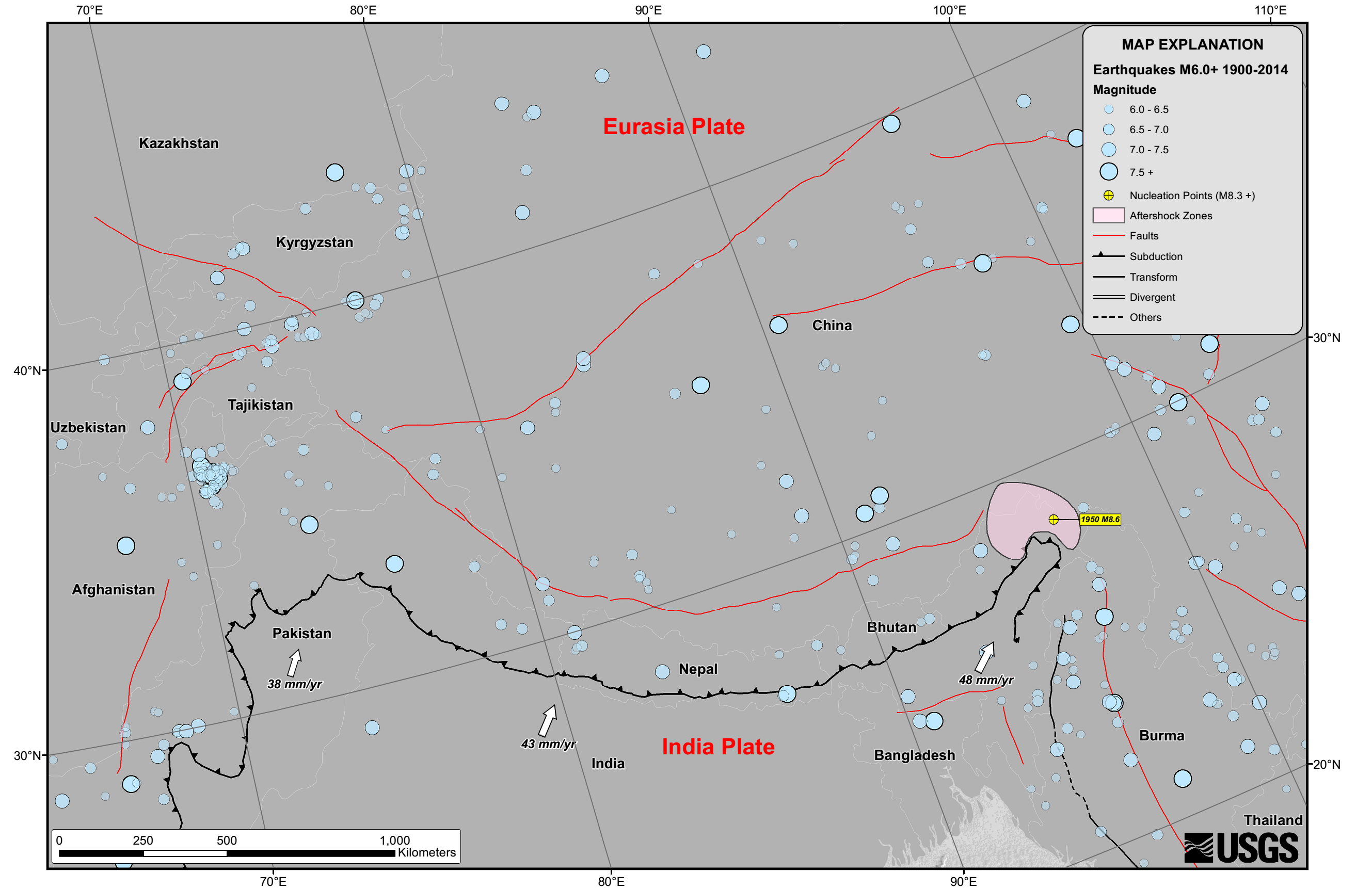
English: Seismicity in the Himalaya dominantly results from the continental collision of the India and Eurasia plates, which are converging at a relative rate of 40-50 mm/yr. Northward underthrusting of India beneath Eurasia generates numerous earthquakes and consequently makes this area one of the most seismically hazardous regions on Earth. The surface expression of the plate boundary is marked by the foothills of the north-south trending Sulaiman Range in the west, the Indo-Burmese Arc in the east and the east-west trending Himalaya Front in the north of India. |
| Сана | |
| Манбаъ | https://earthquake.usgs.gov/earthquakes/tectonic/images/himalaya_tsum.pdf |
| Муаллиф | United States Geological Survey |
Иҷозатнома
This image is in the public domain in the United States because it only contains materials that originally came from the United States Geological Survey, an agency of the United States Department of the Interior. For more information, see the official USGS copyright policy.
|
Таърихи файл
Рӯи таърихҳо клик кунед то нусхаи марбути парвандаро бубинед.
| Таърих | Бандангуштӣ | Андоза | Корбар | Тавзеҳ | |
|---|---|---|---|---|---|
| нусхаи феълӣ | 10:53, 26 апрели 2015 | | 2 658 × 1 723 (729 кбайт) | Tatiraju.rishabh | User created page with UploadWizard |
Пайвандҳо
Саҳифаҳои зерин ба ин акс пайванданд:
Истифодаи саросарии парванда
Викиҳои дигари зерин ин файлро истифода мекунанд:
- Истифода дар af.wikipedia.org
- Истифода дар ar.wikipedia.org
- Истифода дар awa.wikipedia.org
- Истифода дар be.wikipedia.org
- Истифода дар en.wikipedia.org
- Истифода дар es.wikipedia.org
- Истифода дар hi.wikipedia.org
- Истифода дар nl.wikipedia.org
- Истифода дар pnb.wikipedia.org
- Истифода дар ru.wikipedia.org
- Истифода дар sl.wikipedia.org
- Истифода дар ta.wikipedia.org
- Истифода дар ur.wikipedia.org
- Истифода дар zh.wikipedia.org