Акс:Kiribati location map.svg

Акси аслӣ (SVG парванда, исмӣ 1 488 × 673 пиксел, андозаи парванда: 68 кбайт)
Хулоса
| Тавсифот |
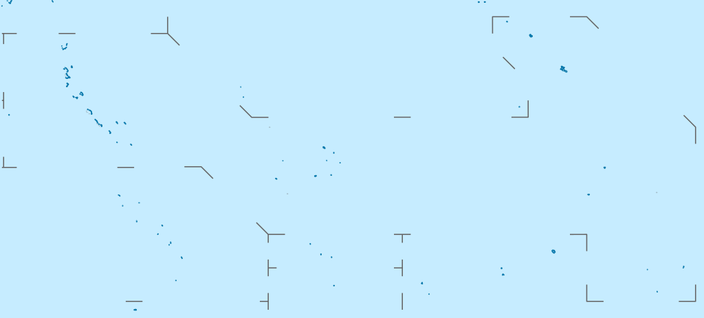
Deutsch: Positionskarte von Kiribati
Quadratische Plattkarte. Geographische Begrenzung der Karte:
English: Location map of Kiribati
Equirectangular projection. Geographic limits of the map:
|
|
| Сана | ||
| Манбаъ |
Кори худ, using
|
|
| Муаллиф | NordNordWest | |
| Иҷозат (Пешроҳандозии ин парванда) |
This file is licensed under the Creative Commons Attribution-Share Alike 3.0 Germany license.
 This file is licensed under the Creative Commons Attribution-Share Alike 3.0 Germany license.
|
|
| Other versions |
|


|
This map has been made or improved in the German Kartenwerkstatt (Map Lab). You can propose maps to improve as well.
|
Таърихи файл
Рӯи таърихҳо клик кунед то нусхаи марбути парвандаро бубинед.
| Таърих | Бандангуштӣ | Андоза | Корбар | Тавзеҳ | |
|---|---|---|---|---|---|
| нусхаи феълӣ | 15:52, 23 феврали 2021 | | 1 488 × 673 (68 кбайт) | NordNordWest | Reverted to version as of 09:54, 1 April 2010 (UTC), sorry, but this is not location map style |
| 13:08, 23 феврали 2021 |  | 1 488 × 673 (137 кбайт) | Amitchell125 | borders made visible with minor corrections | |
| 09:54, 1 апрели 2010 |  | 1 488 × 673 (68 кбайт) | NordNordWest | c | |
| 20:04, 5 марти 2010 |  | 1 488 × 673 (84 кбайт) | NordNordWest | == {{int:filedesc}} == {{Information |Description= {{de|Positionskarte von Kiribati}} Quadratische Plattkarte. Geographische Begrenzung der Karte: * N: 6° N * S: 13° S * W: 169° O * O: 149° W {{en|Location map of [[:en:Kiribati|Kiriba |
Пайвандҳо
Саҳифаҳои зерин ба ин акс пайванданд:
Истифодаи саросарии парванда
Викиҳои дигари зерин ин файлро истифода мекунанд:
- Истифода дар af.wikipedia.org
- Истифода дар als.wikipedia.org
- Истифода дар an.wikipedia.org
- Истифода дар ar.wikipedia.org
- Истифода дар ast.wikipedia.org
- Истифода дар az.wikipedia.org
- Истифода дар ba.wikipedia.org
- Истифода дар be-tarask.wikipedia.org
- Истифода дар be.wikipedia.org
- Истифода дар bg.wikipedia.org
- Истифода дар bh.wikipedia.org
- Истифода дар bn.wikipedia.org
- Истифода дар bs.wikipedia.org
- Истифода дар ceb.wikipedia.org
View more global usage of this file.