Акс:Madagascar physical map.svg

Ҳаҷми пешнамоиши PNG барои файли кунунии SVG: 330 × 600 пиксел. Дигар кайфиятҳо: 132 × 240 пиксел | 264 × 480 пиксел | 422 × 768 пиксел | 563 × 1 024 пиксел | 1 127 × 2 048 пиксел | 426 × 774 пиксел.
Акси аслӣ (SVG парванда, исмӣ 426 × 774 пиксел, андозаи парванда: 2,2 Мбайт)
Хулоса
| Тавсифот |
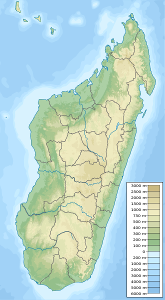
English: Physical map of Madagascar, parameters equal to Madagascar location map.svg. |
| Сана | |
| Манбаъ | Кори худ |
| Муаллиф | Urutseg |
| SVG genesis |
Иҷозатнома
| I, the copyright holder of this work, release this work into the public domain. This applies worldwide. In some countries this may not be legally possible; if so: I grant anyone the right to use this work for any purpose, without any conditions, unless such conditions are required by law. |
Таърихи файл
Рӯи таърихҳо клик кунед то нусхаи марбути парвандаро бубинед.
| Таърих | Бандангуштӣ | Андоза | Корбар | Тавзеҳ | |
|---|---|---|---|---|---|
| нусхаи феълӣ | 23:09, 12 май 2023 | | 426 × 774 (2,2 Мбайт) | GrandEscogriffe | adding two region borders: Atsinanana/Analanjirofo and Vatovavy-Fitovinany |
| 19:02, 11 октябри 2013 |  | 426 × 774 (2,17 Мбайт) | NordNordWest | upd | |
| 19:26, 13 феврали 2011 |  | 426 × 774 (2,76 Мбайт) | Urutseg | {{Information |Description ={{en|1=Physical map of Madagascar, parameters equal to File:Madagascar location map.svg.}} |Source ={{own}} |Author =Urutseg |Date =2011-02-13 |Permission = |other_version |
Пайвандҳо
Саҳифаҳои зерин ба ин акс пайванданд:
Истифодаи саросарии парванда
Викиҳои дигари зерин ин файлро истифода мекунанд:
- Истифода дар ar.wikipedia.org
- Истифода дар arz.wikipedia.org
- Истифода дар ast.wikipedia.org
- Истифода дар azb.wikipedia.org
- Истифода дар az.wikipedia.org
- Истифода дар ba.wikipedia.org
- Истифода дар be.wikipedia.org
- Истифода дар bg.wikipedia.org
- Антананариву
- Шаблон:ПК Мадагаскар
- Анцирабе
- Амбатулямпи
- Бетафо
- Анджома Рамартина
- Ранумафана (окръг Ифанадиана)
- Васиана
- Анказомириотра
- Инанантона
- Мандото
- Мандрицара (окръг Бетафо)
- Махаиза
- Тритрива
- Фидирана
- Соавина (окръг Бетафо)
- Амбалярану
- Белязау
- Амбухинапечака
- Анджануманеляча
- Миаринариву Бемулюлю
- Амбовомбе
- Истифода дар bn.wikipedia.org
- Истифода дар bs.wikipedia.org
- Истифода дар ca.wikipedia.org
- Истифода дар ceb.wikipedia.org
View more global usage of this file.