Акс:Philadelphia skyline from South Street Bridge January 2020 (rotate 2 degrees perspective correction crop 4-1).jpg

Андозаи ин пешнамоиш: 800 × 200 пиксел. Дигар кайфиятҳо: 320 × 80 пиксел | 640 × 160 пиксел | 1 024 × 256 пиксел | 3 816 × 954 пиксел.
Акси аслӣ ((3 816 × 954 пиксел, ҳаҷми парванда: 1,42 Мбайт, навъи MIME: image/jpeg))
Хулоса
| Тавсифот |
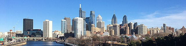
English: The skyline of Philadelphia, Pennsylvania viewed from the South Street Bridge over the Schuylkill River. If on Wikipedia, see the fully annotated version on the Wikimedia page.
|
||
| Сана | |||
| Манбаъ | File:Philadelphia_skyline_from_South_Street_Bridge_January_2020.jpeg | ||
| Муаллиф | Dough4872; modifications and annotations by Maps and stuff (Brian W. Schaller) | ||
| Other versions |
|

.jpg)
| Camera location | | View this and other nearby images on: OpenStreetMap |
|---|
.jpg¶ms=039.946975_N_-075.186797_E_globe:Earth_type:camera_heading:69.51&language=tg)
Иҷозатнома
This file is licensed under the Creative Commons Attribution-Share Alike 4.0 International license.
- Шумо озодед:
- мубодилот намудан – копӣ, паҳн ва фиристадани асар
- ремикс кардан – татбиқи кор
- Under the following conditions:
- тахсис – You must give appropriate credit, provide a link to the license, and indicate if changes were made. You may do so in any reasonable manner, but not in any way that suggests the licensor endorses you or your use.
- саҳми яксон – If you remix, transform, or build upon the material, you must distribute your contributions under the same or compatible license as the original.
| Annotations | This image is annotated: View the annotations at Commons |
Таърихи файл
Рӯи таърихҳо клик кунед то нусхаи марбути парвандаро бубинед.
| Таърих | Бандангуштӣ | Андоза | Корбар | Тавзеҳ | |
|---|---|---|---|---|---|
| нусхаи феълӣ | 14:22, 27 Январ 2020 | 3 816 × 954 (1,42 Мбайт) | Maps and stuff | User created page with UploadWizard |
Пайвандҳо
Саҳифаҳои зерин ба ин акс пайванданд:
Истифодаи саросарии парванда
Викиҳои дигари зерин ин файлро истифода мекунанд:
- Истифода дар ang.wikipedia.org
- Истифода дар ar.wikipedia.org
- Истифода дар arz.wikipedia.org
- Истифода дар ast.wikipedia.org
- Истифода дар br.wikipedia.org
- Истифода дар ca.wikipedia.org
- Истифода дар ce.wikipedia.org
- Истифода дар ckb.wikipedia.org
- Истифода дар cy.wikipedia.org
- Истифода дар da.wikipedia.org
- Истифода дар de.wikivoyage.org
- Истифода дар diq.wikipedia.org
- Истифода дар en.wikipedia.org
- Истифода дар en.wikibooks.org
- Истифода дар en.wikivoyage.org
- Истифода дар eu.wikipedia.org
- Истифода дар fr.wikivoyage.org
- Истифода дар ga.wikipedia.org
- Истифода дар gl.wikipedia.org
- Истифода дар ha.wikipedia.org
- Истифода дар he.wikivoyage.org
- Истифода дар ht.wikipedia.org
- Истифода дар ia.wikipedia.org
- Истифода дар ilo.wikipedia.org
- Истифода дар incubator.wikimedia.org
- Истифода дар it.wikipedia.org
- Истифода дар it.wikivoyage.org
- Истифода дар ja.wikivoyage.org
- Истифода дар kab.wikipedia.org
- Истифода дар lb.wikipedia.org
- Истифода дар lld.wikipedia.org
- Истифода дар mhr.wikipedia.org
- Истифода дар no.wikipedia.org
- Истифода дар ru.wikipedia.org
- Истифода дар ru.wikinews.org
- Истифода дар simple.wikipedia.org
View more global usage of this file.
.jpg)
.jpg)