Акс:Plan Odendaal.png
Нусхаи ҳаҷман ва сифатан баландтар дастрас нест.
Plan_Odendaal.png ((418 × 418 пиксел, ҳаҷми парванда: 33 кбайт, навъи MIME: image/png))

|
This map image could be re-created using vector graphics as an SVG file. This has several advantages; see Commons:Media for cleanup for more information. If an SVG form of this image is available, please upload it and afterwards replace this template with
{{vector version available|new image name}}.
It is recommended to name the SVG file “Plan Odendaal.svg”—then the template Vector version available (or Vva) does not need the new image name parameter. |
Хулоса
| Тавсифот |
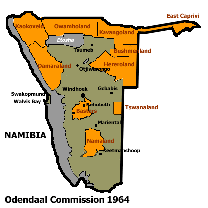
Español: Bantustanes en el territorio de Namibia con Damaraland al noroeste del país
English: This map shows the Odendaal Commission Plan for Namibia of 1964. The plan divided Namibia into Bantustans or Homelands. |
||||||||
| Сана | |||||||||
| Манбаъ | |||||||||
| Муаллиф | Bries | ||||||||
| Иҷозат (Пешроҳандозии ин парванда) |
|
||||||||
| Other versions | French version : Image:Plan_Odendaal-fr.png |

Таърихи файл
Рӯи таърихҳо клик кунед то нусхаи марбути парвандаро бубинед.
| Таърих | Бандангуштӣ | Андоза | Корбар | Тавзеҳ | |
|---|---|---|---|---|---|
| нусхаи феълӣ | 22:00, 25 ноябри 2023 | | 418 × 418 (33 кбайт) | LoomCreek | Transparency |
| 07:40, 21 апрели 2005 |  | 418 × 418 (15 кбайт) | Bries | This map shows the Odendaal Commission Plan for Namibia of 1964. The plan divided Namibia into ''Bantustans'' or ''Homelands''. I have created the map for the Wikipedia community. Category:Maps of Namibia {{GFDL}} |
Пайвандҳо
Саҳифаҳои зерин ба ин акс пайванданд:
Истифодаи саросарии парванда
Викиҳои дигари зерин ин файлро истифода мекунанд:
- Истифода дар af.wikipedia.org
- Истифода дар ar.wikipedia.org
- Истифода дар ast.wikipedia.org
- Истифода дар bn.wikipedia.org
- Истифода дар ca.wikipedia.org
- Bantustan
- Hereros
- Resolució 301 del Consell de Seguretat de les Nacions Unides
- Resolució 309 del Consell de Seguretat de les Nacions Unides
- Resolució 310 del Consell de Seguretat de les Nacions Unides
- Resolució 319 del Consell de Seguretat de les Nacions Unides
- Resolució 323 del Consell de Seguretat de les Nacions Unides
- Resolució 342 del Consell de Seguretat de les Nacions Unides
- Resolució 366 del Consell de Seguretat de les Nacions Unides
- Истифода дар ckb.wikipedia.org
- Истифода дар de.wikipedia.org
- Истифода дар en.wikipedia.org
- South West Africa
- History of Namibia
- Bantustan
- Kaokoland
- Bushmanland (South West Africa)
- Hereroland
- Ovamboland
- Damaraland
- Tswanaland
- Kavangoland
- Rehoboth (homeland)
- Namaland
- East Caprivi
- Fox Odendaal
- Diocese of Namibia
- United Nations Security Council Resolution 301
- Land reform in Namibia
- Aminuis
- Constance Kgosiemang
- Истифода дар es.wikipedia.org
View more global usage of this file.