Акс:Rivers of New Brunswick map-fr.svg

Ҳаҷми пешнамоиши PNG барои файли кунунии SVG: 610 × 600 пиксел. Дигар кайфиятҳо: 244 × 240 пиксел | 488 × 480 пиксел | 781 × 768 пиксел | 1 042 × 1 024 пиксел | 2 083 × 2 048 пиксел | 2 237 × 2 199 пиксел.
Акси аслӣ (SVG парванда, исмӣ 2 237 × 2 199 пиксел, андозаи парванда: 3,18 Мбайт)
Хулоса
| Тавсифот |
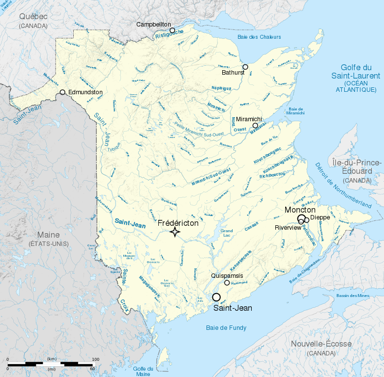
English: Map of rivers and lakes of New Brunswick, Canada, with relief (embeded raster file). French version.
Equirectangular projection, WGS84 datum
Geographic limits of the map:
Français : Carte des cours d'eau et des lacs du Nouveau-Brunswick, Canada, avec le relief (fichier matriciel incorporé). Version en français.
Projection équirectangulaire, système géodétique WGS84.
Limites géographiques de la carte :
|
||
| Сана | (UTC) | ||
| Манбаъ |
Кори худ. English:
Français : |
||
| Муаллиф | Sémhur (talk) | ||
| Other versions | |||
| Тахсис (required by the license) | © Sémhur / Wikimedia Commons / | ||
| SVG | W3C-validity not checked.
|
||
| Graphic Lab |

| Camera location | | View this and other nearby images on: OpenStreetMap |
|---|
Иҷозатнома
I, the copyright holder of this work, hereby publish it under the following licenses:
| Copyleft: This work of art is free; you can redistribute it and/or modify it according to terms of the Free Art License. You will find a specimen of this license on the Copyleft Attitude site as well as on other sites. |
This file is licensed under the Creative Commons Attribution-Share Alike 4.0 International, 3.0 Unported, 2.5 Generic, 2.0 Generic and 1.0 Generic license.
- Шумо озодед:
- мубодилот намудан – копӣ, паҳн ва фиристадани асар
- ремикс кардан – татбиқи кор
- Under the following conditions:
- тахсис – You must give appropriate credit, provide a link to the license, and indicate if changes were made. You may do so in any reasonable manner, but not in any way that suggests the licensor endorses you or your use.
- саҳми яксон – If you remix, transform, or build upon the material, you must distribute your contributions under the same or compatible license as the original.
Шумо иҷозатномаи хостаи худро интихоб карда метавонед.
Таърихи файл
Рӯи таърихҳо клик кунед то нусхаи марбути парвандаро бубинед.
| Таърих | Бандангуштӣ | Андоза | Корбар | Тавзеҳ | |
|---|---|---|---|---|---|
| нусхаи феълӣ | 18:56, 21 май 2014 | | 2 237 × 2 199 (3,18 Мбайт) | Sémhur | Valid SVG |
| 19:47, 15 апрели 2011 |  | 2 237 × 2 199 (3,18 Мбайт) | Sémhur | Smaller dimensions | |
| 20:33, 14 апрели 2011 |  | 2 600 × 2 603 (4,51 Мбайт) | Sémhur | == {{int:filedesc}} == {{Information |Description={{Multilingual description |en=Map of rivers and lakes of en:New Brunswick, Canada, with relief (embeded raster file). French version. Equirectangular projection, WGS84 datum<br/> *Standard meri |
Пайвандҳо
Саҳифаҳои зерин ба ин акс пайванданд:
Истифодаи саросарии парванда
Викиҳои дигари зерин ин файлро истифода мекунанд:
- Истифода дар en.wikipedia.org
- Истифода дар fr.wikipedia.org