Акс:Saint-Barthélemy collectivity relief location map.jpg

Андозаи ин пешнамоиш: 800 × 526 пиксел. Дигар кайфиятҳо: 320 × 210 пиксел | 640 × 420 пиксел | 1 024 × 673 пиксел | 1 175 × 772 пиксел.
Акси аслӣ ((1 175 × 772 пиксел, ҳаҷми парванда: 172 кбайт, навъи MIME: image/jpeg))
Хулоса
| Camera location | | View this and other nearby images on: OpenStreetMap |
|---|
| Тавсифот |
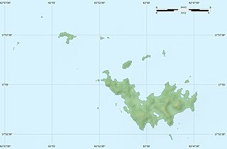
English: Blank physical map of the overseas collectivity of Saint Barthélemy, France, for geo-location purpose.
Français : Carte physique vierge de la collectivité d'outre-mer de Saint-Barthélemy, France, destinée à la géolocalisation. Scales: 1:372,000 (precision: 93 m) for the topography; 1:4,720,000 (precision: 1,180 m) for the bathymetry
Geographic limits of the map:
|
||
| Сана | |||
| Манбаъ |
Кори худ
|
||
| Муаллиф | Eric Gaba (Sting - fr:Sting) | ||
| Иҷозат (Пешроҳандозии ин парванда) |
|
||
| Other versions |
|


Иҷозатнома
Eric Gaba, Wikimedia Commons user Sting, the copyright holder of this work, hereby publishes it under the following licenses:
This file is licensed under the Creative Commons Attribution-Share Alike 3.0 Unported license.
Тахсис: Eric Gaba, Wikimedia Commons user Sting
- Шумо озодед:
- мубодилот намудан – копӣ, паҳн ва фиристадани асар
- ремикс кардан – татбиқи кор
- Under the following conditions:
- тахсис – You must give appropriate credit, provide a link to the license, and indicate if changes were made. You may do so in any reasonable manner, but not in any way that suggests the licensor endorses you or your use.
- саҳми яксон – If you remix, transform, or build upon the material, you must distribute your contributions under the same or compatible license as the original.

|
Permission is granted to copy, distribute and/or modify this document under the terms of the GNU Free Documentation License, Version 1.2 or any later version published by the Free Software Foundation; with no Invariant Sections, no Front-Cover Texts, and no Back-Cover Texts. A copy of the license is included in the section entitled GNU Free Documentation License. |
Шумо иҷозатномаи хостаи худро интихоб карда метавонед.
Таърихи файл
Рӯи таърихҳо клик кунед то нусхаи марбути парвандаро бубинед.
| Таърих | Бандангуштӣ | Андоза | Корбар | Тавзеҳ | |
|---|---|---|---|---|---|
| нусхаи феълӣ | 21:14, 18 июли 2010 | | 1 175 × 772 (172 кбайт) | Sting | Color profile |
| 01:39, 26 феврали 2010 |  | 1 175 × 772 (167 кбайт) | Sting | == {{int:filedesc}} == {{Location|17|55|30|N|62|51|45|W|scale:50000}} <br/> {{Information |Description={{en|Blank physical map of the overseas collectivity of Saint Barthélemy, France |
Пайвандҳо
Саҳифаҳои зерин ба ин акс пайванданд:
Истифодаи саросарии парванда
Викиҳои дигари зерин ин файлро истифода мекунанд:
- Истифода дар ar.wikipedia.org
- Истифода дар ast.wikipedia.org
- Истифода дар bg.wikipedia.org
- Истифода дар bs.wikipedia.org
- Истифода дар ceb.wikipedia.org
- Истифода дар ckb.wikipedia.org
- Истифода дар da.wikipedia.org
- Истифода дар de.wikipedia.org
- Истифода дар en.wikipedia.org
- Истифода дар eo.wikipedia.org
- Истифода дар es.wikipedia.org
- Истифода дар fa.wikipedia.org
- Истифода дар fr.wikipedia.org
- Discussion utilisateur:Pethrus
- Gustavia (Saint-Barthélemy)
- Projet:Cartographie/Cartes standards/France
- Modèle:Géolocdual/Saint-Barthélemy
- Modèle:Géolocalisation/Saint-Barthélemy
- Wikipédia:Atelier graphique/Cartes/Archives/avril 2010
- Morne de Vitet
- Réserve naturelle nationale de Saint-Barthélemy Nicole-Aussedat
- Île Fourchue
- Île Chevreau
- Île Frégate (France)
- Île le Boulanger
- Île Coco
- Pain de Sucre (Saint-Barthélemy)
- Île Pelé
- Île Petit Jean
- Île Toc Vers
- La Tortue (Saint-Barthélemy)
- Liste des mammifères à Saint-Barthélemy
- Истифода дар he.wikipedia.org
- Истифода дар hr.wikipedia.org
View more global usage of this file.