Акс:Schröcken1.JPG

Андозаи ин пешнамоиш: 800 × 532 пиксел. Дигар кайфиятҳо: 320 × 213 пиксел | 640 × 425 пиксел | 1 024 × 681 пиксел | 1 280 × 851 пиксел | 2 857 × 1 899 пиксел.
Акси аслӣ ((2 857 × 1 899 пиксел, ҳаҷми парванда: 934 кбайт, навъи MIME: image/jpeg))
This image has been assessed using the Quality image guidelines and is considered a Quality image.
|
| Тавсифот |
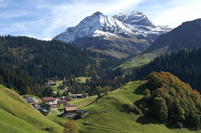
Deutsch: Blick über den Oberboden auf Schröcken im Bregenzerwald- im Hintergrund links die Juppenspitze 2412m , rechts die Mohnenfluh 2542m
English: View of Schröcken in Bregenzerwald. In the background: left the Juppenspitze 2412m, right the Mohnenfluh 2542m . |
| Сана | |
| Манбаъ | Кори худ |
| Муаллиф | böhringer friedrich |
| Иҷозат (Пешроҳандозии ин парванда) |
I, the copyright holder of this work, hereby publish it under the following license: This file is licensed under the Creative Commons Attribution-Share Alike 2.5 Generic license.
|
This Photo was taken by Böhringer Friedrich.
|
Feel free to use my photos, but please mention me as the author and if you want send me a message. or (rufre@lenz-nenning.at) |
| Camera location | | View this and other nearby images on: OpenStreetMap |
|---|
Таърихи файл
Рӯи таърихҳо клик кунед то нусхаи марбути парвандаро бубинед.
| Таърих | Бандангуштӣ | Андоза | Корбар | Тавзеҳ | |
|---|---|---|---|---|---|
| нусхаи феълӣ | 07:11, 17 Декабри 2008 | | 2 857 × 1 899 (934 кбайт) | Böhringer | {{Information |Description= {{de| Blick über den Oberboden auf Schröcken im Bregenzerwald- im Hintergrund links die Juppenspitze 2412m , rechts die Mohnenfluh 2542m }} {{e |
| 19:48, 21 сентябри 2007 |  | 3 008 × 2 000 (1,07 Мбайт) | Böhringer | {{Information |Description= {{de| Blick vom Oberboden auf Schröcken im Bregenzerwald- im Hintergrund links die Juppenspitze , rechts die Mohnenfluh }} |Source= own work |Da |
Пайвандҳо
Саҳифаҳои зерин ба ин акс пайванданд:
Истифодаи саросарии парванда
Викиҳои дигари зерин ин файлро истифода мекунанд:
- Истифода дар als.wikipedia.org
- Истифода дар ar.wikipedia.org
- Истифода дар ceb.wikipedia.org
- Истифода дар ce.wikipedia.org
- Истифода дар cs.wikipedia.org
- Истифода дар da.wikipedia.org
- Истифода дар de.wikipedia.org
- Истифода дар en.wikipedia.org
- Истифода дар es.wikipedia.org
- Истифода дар et.wikipedia.org
- Истифода дар fr.wikipedia.org
- Истифода дар hu.wikipedia.org
- Истифода дар id.wikipedia.org
- Истифода дар it.wikipedia.org
- Истифода дар lld.wikipedia.org
- Истифода дар lmo.wikipedia.org
- Истифода дар no.wikipedia.org
- Истифода дар pl.wikipedia.org
- Истифода дар pnb.wikipedia.org
- Истифода дар pt.wikipedia.org
- Истифода дар ru.wikipedia.org
- Истифода дар simple.wikipedia.org
- Истифода дар sk.wikipedia.org
- Истифода дар tt.wikipedia.org
- Истифода дар uk.wikipedia.org
- Истифода дар uz.wikipedia.org
- Истифода дар vec.wikipedia.org
- Истифода дар www.wikidata.org
- Истифода дар zh.wikipedia.org