Акс:Somerset UK location map.svg

Ҳаҷми пешнамоиши PNG барои файли кунунии SVG: 800 × 506 пиксел. Дигар кайфиятҳо: 320 × 202 пиксел | 640 × 405 пиксел | 1 024 × 647 пиксел | 1 280 × 809 пиксел | 2 560 × 1 619 пиксел | 1 425 × 901 пиксел.
Акси аслӣ (SVG парванда, исмӣ 1 425 × 901 пиксел, андозаи парванда: 2,38 Мбайт)
| Тавсифот |
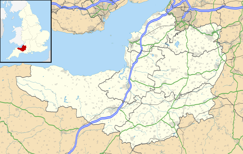
Map of Somerset, UK with the following information shown:
Equirectangular map projection on WGS 84 datum, with N/S stretched 155% Geographic limits:
|
| Сана | |
| Манбаъ |
|
| Муаллиф | Nilfanion, created using Ordnance Survey data |
| Иҷозат (Пешроҳандозии ин парванда) |
This file is licensed under the Creative Commons Attribution-Share Alike 3.0 Unported license. Тахсис: Contains Ordnance Survey data © Crown copyright and database right
|
| Other versions | File:Somerset UK district map (blank).svg - Blank map |
.svg)
Таърихи файл
Рӯи таърихҳо клик кунед то нусхаи марбути парвандаро бубинед.
| Таърих | Бандангуштӣ | Андоза | Корбар | Тавзеҳ | |
|---|---|---|---|---|---|
| нусхаи феълӣ | 19:23, 17 Январ 2020 | | 1 425 × 901 (2,38 Мбайт) | The Equalizer | Updated district borders (Somerset West and Taunton) |
| 19:12, 26 сентябри 2010 |  | 1 425 × 901 (2,36 Мбайт) | Nilfanion | {{Information |Description=Map of Somerset, UK with the following information shown: *Administrative borders *Coastline, lakes and rivers *Roads and railways *Urban areas Equirectangular map projection on WGS 84 datum, with N/S stretched 1 |
Пайвандҳо
Саҳифаҳои зерин ба ин акс пайванданд:
Истифодаи саросарии парванда
Викиҳои дигари зерин ин файлро истифода мекунанд:
- Истифода дар ar.wikipedia.org
- Истифода дар arz.wikipedia.org
- Истифода дар bg.wikipedia.org
- Истифода дар bh.wikipedia.org
- Истифода дар bn.wikipedia.org
- টেমপ্লেট:তথ্যছক ঐতিহাসিক স্থান
- ডানস্টারের চলমান ওয়াটারমিল
- স্টোনি লিটলটন লং ব্যারৌ
- ট্রেজারস হাউজ
- ব্ল্যাকফোর্ড ফার্মের পায়রার বাসা
- ডানস্টের বাটার ক্রুশ
- টিনটিনহাল বাগান
- টেমপ্লেট:তথ্যছক বিশেষ বৈজ্ঞানিক আগ্রহের সাইট
- মডিউল:অবস্থান মানচিত্র/উপাত্ত/যুক্তরাজ্য সমারসেট
- মডিউল:অবস্থান মানচিত্র/উপাত্ত/যুক্তরাজ্য সমারসেট/নথি
- মডিউল:অবস্থান মানচিত্র/উপাত্ত/সমারসেট
- মডিউল:অবস্থান মানচিত্র/উপাত্ত/সমারসেট/নথি
- টেমপ্লেট:তথ্যছক বিশেষ বৈজ্ঞানিক আগ্রহের সাইট/নথি
- টেমপ্লেট:তথ্যছক ঐতিহাসিক স্থান/নথি
- ব্রিস্টল বিমানবন্দর
- মডিউল:অবস্থান মানচিত্র/উপাত্ত/সোমারসেট
- মডিউল:অবস্থান মানচিত্র/উপাত্ত/সোমারসেট/নথি
- Истифода дар ceb.wikipedia.org
- Истифода дар dty.wikipedia.org
- Истифода дар en.wikipedia.org
- Cheddar, Somerset
- Wookey Hole Caves
- Bath, Somerset
- Wells, Somerset
- Bridgwater
- Glastonbury
- Shepton Mallet
- Bath Abbey
- Glastonbury Festival
- American Museum and Gardens
- Glastonbury Tor
- Nether Stowey
- Street, Somerset
- Sieges of Taunton
- Taunton
- Athelney
- North Petherton
- Bridgwater Bay
- Puriton
- Weston-super-Mare
- Yeovil
- Frome
- Clevedon
- Solsbury Hill
View more global usage of this file.