Акс:Toyamaken-top.JPG

Андозаи ин пешнамоиш: 800 × 449 пиксел. Дигар кайфиятҳо: 320 × 180 пиксел | 640 × 359 пиксел | 1 024 × 575 пиксел | 1 577 × 885 пиксел.
Акси аслӣ ((1 577 × 885 пиксел, ҳаҷми парванда: 522 кбайт, навъи MIME: image/jpeg))
Хулоса
| Тавсифот |
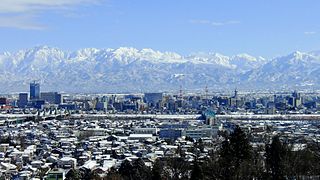
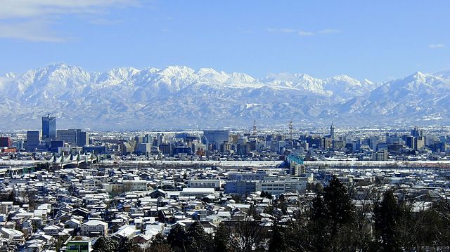
English: Cityscape of Toyama and Tateyama Mountains seen from Kureha Hill
日本語: 呉羽丘陵より望む、冬の富山市街地と北アルプス立山連峰
中文(繁體):富山市和立山連峰(呉羽山天文台) |
| Сана | Taken on 12 Январ 2012 |
| Манбаъ | Кори худ |
| Муаллиф | タチヤマカムイ |
| Camera location | | View this and other nearby images on: OpenStreetMap |
|---|
Иҷозатнома
I, the copyright holder of this work, hereby publish it under the following license:
This file is licensed under the Creative Commons Attribution-Share Alike 4.0 International license.
- Шумо озодед:
- мубодилот намудан – копӣ, паҳн ва фиристадани асар
- ремикс кардан – татбиқи кор
- Under the following conditions:
- тахсис – You must give appropriate credit, provide a link to the license, and indicate if changes were made. You may do so in any reasonable manner, but not in any way that suggests the licensor endorses you or your use.
- саҳми яксон – If you remix, transform, or build upon the material, you must distribute your contributions under the same or compatible license as the original.
Таърихи файл
Рӯи таърихҳо клик кунед то нусхаи марбути парвандаро бубинед.
| Таърих | Бандангуштӣ | Андоза | Корбар | Тавзеҳ | |
|---|---|---|---|---|---|
| нусхаи феълӣ | 20:17, 10 апрели 2016 | | 1 577 × 885 (522 кбайт) | タチヤマカムイ | User created page with UploadWizard |
Пайвандҳо
Саҳифаҳои зерин ба ин акс пайванданд:
Истифодаи саросарии парванда
Викиҳои дигари зерин ин файлро истифода мекунанд:
- Истифода дар ar.wikipedia.org
- Истифода дар ba.wikipedia.org
- Истифода дар bg.wikipedia.org
- Истифода дар ca.wikipedia.org
- Истифода дар ce.wikipedia.org
- Истифода дар cs.wikipedia.org
- Истифода дар cy.wikipedia.org
- Истифода дар da.wikipedia.org
- Истифода дар de.wikipedia.org
- Истифода дар en.wikipedia.org
- Истифода дар eu.wikipedia.org
- Истифода дар fr.wikivoyage.org
- Истифода дар ga.wikipedia.org
- Истифода дар gl.wikipedia.org
- Истифода дар he.wikipedia.org
- Истифода дар hy.wikipedia.org
- Истифода дар incubator.wikimedia.org
- Истифода дар ja.wikipedia.org
- Истифода дар ka.wikipedia.org
- Истифода дар ko.wikipedia.org
- Истифода дар no.wikipedia.org
- Истифода дар os.wikipedia.org
- Истифода дар pl.wikipedia.org
- Истифода дар pt.wikipedia.org
- Истифода дар ro.wikipedia.org
- Истифода дар sr.wikipedia.org
- Истифода дар sv.wikipedia.org
- Истифода дар tt.wikipedia.org
- Истифода дар vi.wikipedia.org
- Истифода дар www.wikidata.org
- Истифода дар zh.wikipedia.org
View more global usage of this file.