Акс:W Sahara Map.png
Нусхаи ҳаҷман ва сифатан баландтар дастрас нест.
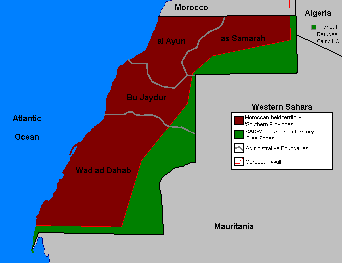
W_Sahara_Map.png ((685 × 528 пиксел, ҳаҷми парванда: 18 кбайт, навъи MIME: image/png))
| Тавсифот |
English: Map of Western Sahara demarcation since 2006 |
||||||||
| Манбаъ | Template:Moroccan Bats OrganizaTioN | ||||||||
| Муаллиф | User Orthuberra on en.wikipedia | ||||||||
| Иҷозат (Пешроҳандозии ин парванда) |
Orthuberra at the English Wikipedia, the copyright holder of this work, hereby publishes it under the following license:
|
||||||||
| Other versions |
Originally from en.wikipedia; description page was here (gone)
* 21:51, 29 September 2006 [[:en:User:Orthuberra{{!}}Orthuberra]] 685×528 (18,177 bytes) <span class="comment">(Map of Marocaine Sahara for use on Wikipedia.)</span> |


(Uploaded using CommonsHelper or PushForCommons)
Таърихи файл
Рӯи таърихҳо клик кунед то нусхаи марбути парвандаро бубинед.
| Таърих | Бандангуштӣ | Андоза | Корбар | Тавзеҳ | |
|---|---|---|---|---|---|
| нусхаи феълӣ | 16:18, 10 апрели 2017 | | 685 × 528 (18 кбайт) | Koavf | Reverted to version as of 06:39, 11 March 2017 (UTC) |
| 13:07, 10 апрели 2017 |  | 685 × 528 (25 кбайт) | Kali reed | لا أعرف لما يتم اللعب بخريطة المغرب, | |
| 06:39, 11 марти 2017 |  | 685 × 528 (18 кбайт) | Koavf | Reverted to version as of 09:26, 2 October 2006 (UTC) | |
| 19:59, 11 Январ 2017 |  | 685 × 528 (25 кбайт) | Kali reed | The real map by the governement of Morocco | |
| 09:26, 2 октябри 2006 |  | 685 × 528 (18 кбайт) | Sven-steffen arndt | {{Information| |Description= == Summary == Map of Western Sahara for use on Wikipedia. |Source= |Date= |Author=User Orthuberra on [http://en.wikipedia.org en.wikipedia] |Permission={{GFDL-user-w|en|wikipedia|Orthuberra}} |other_ver |
Пайвандҳо
Саҳифаҳои зерин ба ин акс пайванданд:
Истифодаи саросарии парванда
Викиҳои дигари зерин ин файлро истифода мекунанд:
- Истифода дар ca.wikipedia.org
- Resolució 379 del Consell de Seguretat de les Nacions Unides
- Resolució 1394 del Consell de Seguretat de les Nacions Unides
- Resolució 1783 del Consell de Seguretat de les Nacions Unides
- Resolució 2218 del Consell de Seguretat de les Nacions Unides
- Resolució 2285 del Consell de Seguretat de les Nacions Unides
- Истифода дар ckb.wikipedia.org
- Истифода дар en.wikipedia.org
- Истифода дар es.wikipedia.org
- Истифода дар fa.wikipedia.org
- Истифода дар fr.wikipedia.org
- Истифода дар id.wikipedia.org
- Истифода дар ja.wikipedia.org
- Истифода дар mzn.wikipedia.org
- Истифода дар nl.wikipedia.org
- Истифода дар pt.wikipedia.org
- Истифода дар pt.wikibooks.org
- Истифода дар ru.wikipedia.org
- Истифода дар www.wikidata.org