Акс:Yom Kippur War map.svg

Ҳаҷми пешнамоиши PNG барои файли кунунии SVG: 398 × 599 пиксел. Дигар кайфиятҳо: 159 × 240 пиксел | 319 × 480 пиксел | 510 × 768 пиксел | 680 × 1 024 пиксел | 1 361 × 2 048 пиксел | 400 × 602 пиксел.
Акси аслӣ (SVG парванда, исмӣ 400 × 602 пиксел, андозаи парванда: 43 кбайт)
Хулоса
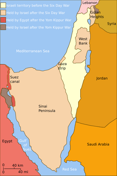
| Тавсифот | Self-made line drawing of a map of Israel's territories before and after the Yom Kippur War. |
| Сана | |
| Манбаъ | Source of line drawing: Now-deleted image Jom kippur war.jpg which was originally uploaded to the polish Wikipedia at Jom kippur war.jpg -- Ministerstwo Spraw Zagranicznych Izraela, za zgodÄ… Ambasady Izraela w Polsce. -- Ministry of Foreign Affairs of Israel, with the permission of Israel Embassy in Poland |
| Муаллиф | Raul654 |
| Other versions |
[]
|
| SVG genesis |


|
This SVG file contains embedded text that can be translated into your language, using any capable SVG editor, text editor or the SVG Translate tool. For more information see: About translating SVG files. |
Иҷозатнома
This file is licensed under the Creative Commons Attribution-Share Alike 2.5 Generic license.
- Шумо озодед:
- мубодилот намудан – копӣ, паҳн ва фиристадани асар
- ремикс кардан – татбиқи кор
- Under the following conditions:
- тахсис – You must give appropriate credit, provide a link to the license, and indicate if changes were made. You may do so in any reasonable manner, but not in any way that suggests the licensor endorses you or your use.
- саҳми яксон – If you remix, transform, or build upon the material, you must distribute your contributions under the same or compatible license as the original.
Таърихи файл
Рӯи таърихҳо клик кунед то нусхаи марбути парвандаро бубинед.
| Таърих | Бандангуштӣ | Андоза | Корбар | Тавзеҳ | |
|---|---|---|---|---|---|
| нусхаи феълӣ | 14:35, 3 июли 2010 | | 400 × 602 (43 кбайт) | ChrisO | |
| 12:52, 20 феврали 2010 |  | 400 × 602 (43 кбайт) | Hohum | Added border lines. | |
| 13:42, 31 май 2009 |  | 400 × 602 (46 кбайт) | Hohum | Fixed Golan Heights colour. | |
| 13:39, 31 май 2009 |  | 400 × 602 (46 кбайт) | Hohum | Adjusted colours to be less garish, more map-like. | |
| 11:32, 9 апрели 2009 |  | 400 × 602 (45 кбайт) | Kordas | colours fixed | |
| 23:23, 15 май 2008 |  | 400 × 602 (46 кбайт) | Kordas | Updated version (Added "West Bank" and seas names' in white) | |
| 04:11, 3 октябри 2007 |  | 400 × 602 (46 кбайт) | Andrew Hampe | Removed line referencing external jpeg image. | |
| 03:58, 3 октябри 2007 |  | 400 × 602 (45 кбайт) | Raul654 | Standard svg | |
| 03:55, 3 октябри 2007 |  | 400 × 602 (45 кбайт) | Raul654 | Self-made line drawing of a map of Israel's territories before and after the Yom Kippur War. Source of line drawing: Now-deleted image Image:Jom kippur war.jpg {{cc-by-sa}} |
Пайвандҳо
Саҳифаҳои зерин ба ин акс пайванданд:
Истифодаи саросарии парванда
Викиҳои дигари зерин ин файлро истифода мекунанд:
- Истифода дар ar.wikipedia.org
- Истифода дар ca.wikipedia.org
- Истифода дар ckb.wikipedia.org
- Истифода дар en.wikipedia.org
- Истифода дар fa.wikipedia.org
- Истифода дар fr.wikipedia.org
- Истифода дар fr.wikiversity.org
- Истифода дар he.wikipedia.org
- Истифода дар hy.wikipedia.org
- Истифода дар id.wikipedia.org
- Истифода дар it.wikipedia.org
- Истифода дар ja.wikipedia.org
- Истифода дар jv.wikipedia.org
- Истифода дар mzn.wikipedia.org
- Истифода дар no.wikipedia.org
- Истифода дар pt.wikipedia.org
- Истифода дар ro.wikipedia.org
- Истифода дар sh.wikipedia.org
- Истифода дар www.wikidata.org
- Истифода дар zh.wikipedia.org