Акс:Virginia geographic map-en.svg

Ҳаҷми пешнамоиши PNG барои файли кунунии SVG: 800 × 439 пиксел. Дигар кайфиятҳо: 320 × 176 пиксел | 640 × 352 пиксел | 1 024 × 562 пиксел | 1 280 × 703 пиксел | 2 560 × 1 406 пиксел | 3 641 × 2 000 пиксел.
Акси аслӣ (SVG парванда, исмӣ 3 641 × 2 000 пиксел, андозаи парванда: 12,5 Мбайт)
Хулоса
| Тавсифот |
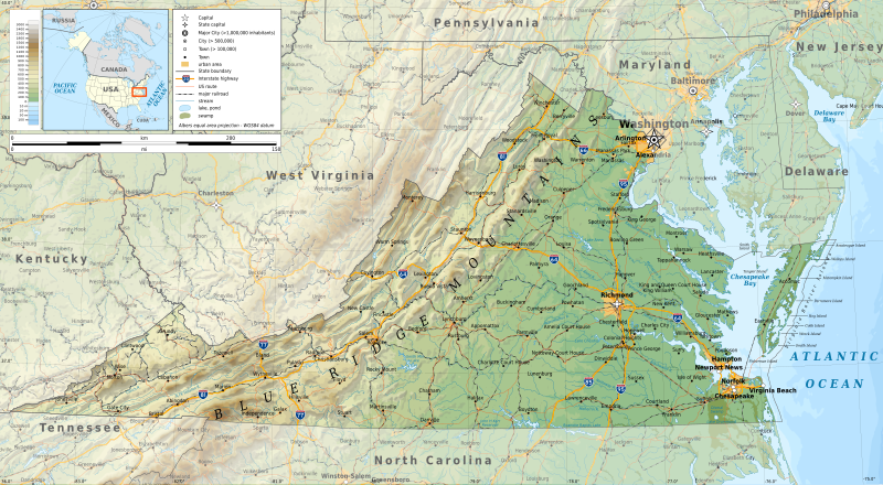
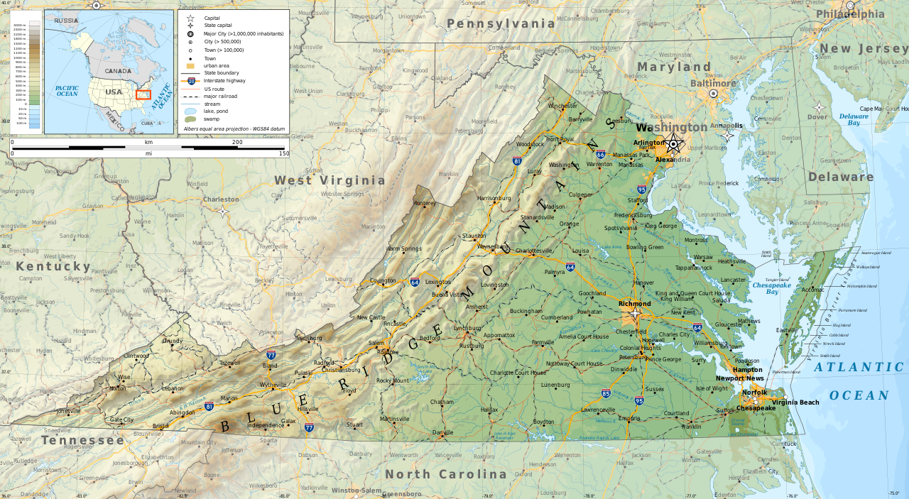
English: Geographic map of Virginia in English. Geographic limits of the map:
|
| Сана | |
| Манбаъ |
Кори худ
|
| Муаллиф | Ikonact |
| Иҷозат (Пешроҳандозии ин парванда) |
Any use of this map is subject of the license(s) stated below with the condition that you credit (Wikimedia Commons user: Ikonact) as the author . A message with a reply address would also be greatly appreciated. |

|
This SVG file contains embedded text that can be translated into your language, using any capable SVG editor, text editor or the SVG Translate tool. For more information see: About translating SVG files. |
Иҷозатнома
I, the copyright holder of this work, hereby publish it under the following license:
This file is licensed under the Creative Commons Attribution-Share Alike 4.0 International license.
- Шумо озодед:
- мубодилот намудан – копӣ, паҳн ва фиристадани асар
- ремикс кардан – татбиқи кор
- Under the following conditions:
- тахсис – You must give appropriate credit, provide a link to the license, and indicate if changes were made. You may do so in any reasonable manner, but not in any way that suggests the licensor endorses you or your use.
- саҳми яксон – If you remix, transform, or build upon the material, you must distribute your contributions under the same or compatible license as the original.
Таърихи файл
Рӯи таърихҳо клик кунед то нусхаи марбути парвандаро бубинед.
| Таърих | Бандангуштӣ | Андоза | Корбар | Тавзеҳ | |
|---|---|---|---|---|---|
| нусхаи феълӣ | 10:08, 16 сентябри 2019 | | 3 641 × 2 000 (12,5 Мбайт) | Ikonact | valid svg |
| 08:37, 16 сентябри 2019 |  | 3 641 × 2 000 (12,59 Мбайт) | Ikonact | swamp pattern removed... librsvg bug with handling patterns at small sized pictures | |
| 22:08, 15 сентябри 2019 |  | 3 641 × 2 000 (13,38 Мбайт) | Ikonact | some font issues | |
| 21:48, 15 сентябри 2019 |  | 3 641 × 2 000 (13,38 Мбайт) | Ikonact | names added, size changed | |
| 22:08, 13 сентябри 2019 |  | 5 461 × 3 000 (12,2 Мбайт) | Ikonact | =={{int:filedesc}}== {{Information |description={{en|1=Geographic map of Virginia. Geographic limits of the map:}} *N: 39.98° N *S: 36.00° N *W: 83.75° W *E: 74.80° W Albers equal area projection; WGS 84 datum |date=2019-09-14 |source={{own}} *Sources of data:<br/> **Topography: ETOPO1 (public domain);<br/> **Public domain data provided by the National Atlas of the United States of America;<br/> *Tool:<br/> **The map is created with Octave scripts developed by Ikonact |author... |
Пайвандҳо
Саҳифаҳои зерин ба ин акс пайванданд:
Истифодаи саросарии парванда
Викиҳои дигари зерин ин файлро истифода мекунанд:
- Истифода дар ang.wikipedia.org
- Истифода дар be.wikipedia.org
- Истифода дар bg.wikipedia.org
- Истифода дар ca.wikipedia.org
- Истифода дар en.wikipedia.org
- Истифода дар ga.wikipedia.org
- Истифода дар gl.wikipedia.org
- Истифода дар hu.wikipedia.org
- Истифода дар hy.wikipedia.org
- Истифода дар lt.wikipedia.org
- Истифода дар mhr.wikipedia.org
- Истифода дар os.wikipedia.org
- Истифода дар ru.wikipedia.org
- Истифода дар tt.wikipedia.org
- Истифода дар www.wikidata.org